Page 265
     
 
  Earth Science:
The Atmosphere and the Hydroshpere


  The earth sciences include the study of earth's atmosphere, the layer of gases surrounding the earth, and the hydrosphere, the water contained in oceans, rivers, lakes, and groundwater. Subdisciplines such as atmospheric physics, meteorology, oceanography, and hydrology study the processes and phenomena of earth's atmosphere and hydrosphere.  


  Earth science is also concerned with how the atmosphere and hydrosphere interact with earth's lithosphere, affecting the c0016-01.gifgeomorphology of the planet's surface. Weathering, running water, waves, glacial ice, and wind—which result in the erosion, transportation, and deposition of rocks and soils—influence the form of earth's surface. For example, the shape of a mountain range is largely the result of erosive processes that progressively remove material from the mountain range.  


  Erosion  


  The wearing away of the earth's surface is called erosion. It is caused by the breakdown and transport of particles of rock or soil. By contrast, weathering does not involve transport. Water, consisting of sea waves and currents, rivers, and rain; ice, in the form of glaciers; and wind, hurling sand fragments against exposed rocks and moving dunes along, are the most potent forces of erosion. There are four processes of erosion: c0016-01.gifhydraulic action, c0016-01.gifcorrasion, c0016-01.gifattrition, and c0016-01.gifsolution.  


  The form that erosion takes, and the degree to which it takes place, can vary with rock type. Unconsolidated sands and gravel are more easily eroded than solid granite, while rocks such as limestone are worn down by chemical processes rather than by physical forces.  


  weathering  


  Weathering is the process by which exposed rocks are broken down on the spot by the action of rain, frost, wind, and other elements of the weather. It differs from erosion in that no movement or transportation of the broken-down material takes place. Two types of weathering are recognized: physical (or mechanical) and chemical. They usually occur together.  
 
Weathering
Physical weathering  
 
 
  temperature changes  
 
weakening rocks by expansion and contraction
 
 
  frost  
 
wedging rocks apart by the expansion of water on freezing
 
 
  unloading  
 
the loosening of rock layers by release of pressure after the erosion and removal of those layers above
Chemical weathering  
 
 
  carbonation  
 
breakdown of calcite by reaction with carbonic acid in rainwater
 
 
  hydrolysis  
 
breakdown of feldspar into china clay by reaction with carbonic acid in rainwater
 
 
  oxidation  
 
breakdown of iron-rich minerals due to rusting
 
 
  hydration  
 
expansion of certain minerals due to the uptake of water


Page 266
   
 
  transportation and deposition  


  After materials have been broken down and loosened by weathering, they are transported by mass movement, wind action, or running water, and deposited to new locations; glaciers transport materials embedded in them, winds lift dust particles and carry them over great distances, precipitation falling on sloping land shifts soils downhill, water currents carry materials along a riverbed or out to sea. Through deposition, the particles accumulate elsewhere; rivers and glaciers carve valleys and deposit eroded material in plains and deltas, desert winds wear away rock and form huge sand dunes, waves erode rocky shorelines and create sandy beaches. River c0016-01.gifdeltas such as those of the Nile and the Ganges, which are formed by the buildup of silt at the point where the river meets the sea, demonstrate the cumulative effects on landform of transportation and deposition.  


  Earth's Atmosphere  


  An atmosphere is mixture of gases surrounding a planet. Planetary atmospheres are prevented from escaping by the pull of gravity. On earth, atmospheric pressure decreases with altitude. In its lowest layer, earth's atmosphere consists of nitrogen (78%) and oxygen (21%), both in molecular form (two atoms bonded together) and 1% argon. Small quantities of other gases are important to the chemistry and physics of the earth's atmosphere, including water and carbon dioxide. The atmosphere plays a major part in the various cycles of nature (the water cycle, the c0016-01.gifcarbon cycle, and the nitrogen cycle). It is the principal industrial source of nitrogen, oxygen, and argon, which are obtained by fractional distillation of liquid air.  


  earth's atmosphere is divided into four regions of atmosphere classified by temperature. The thermal structure of the earth's atmosphere is the result of a complex interaction between the electromagnetic radiation from the sun, radiation reflected from the earth's surface, and molecules and atoms in the atmosphere.  


  layers of the atmosphere  


  troposphere The troposphere is the lowest level of the atmosphere (altitudes from 0 to 10 km/6 mi) and is heated to an average temperature of 15°C/59°F by the earth, which in turn is warmed by infrared and visible radiation from the sun. Warm air cools as it rises in the troposphere and this rising of warm air causes rain and most other weather phenomena. The top of the troposphere is approximately –60°C/–76°F. The temperature minimum between the troposphere and the stratosphere above marks the influence of the earth's warming effects and is called the tropopause.  


  stratosphere  


  Temperature increases with altitude in the stratosphere, the layer (from 10 km/6 mi to 50 km/31 mi) above the troposphere. Temperatures rise in the stratosphere from –60°C/–76°F to near 0°C/32°F. The temperature maximum near the top of the stratosphere is called the stratopause. Here, temperatures rise as ultraviolet photons are absorbed by heavier molecules to form new gases. An important example is the production of ozone molecules (oxygen atom triplets, O3) from oxygen molecules. Ozone is a better absorber of ultraviolet radiation than ordinary (two-atom) oxygen, and it is the ozone layer within the stratosphere that prevents lethal amounts of ultraviolet from reaching the earth's surface.  


  mesosphere Temperature again decreases with altitude through the mesosphere (50 km/31 mi to 80 km/ 50 mi), from 0°C/32°F to below –100°C/–212°F.  


  thermosphere The thermosphere is the highest layer of the atmosphere (80 km/50 mi to about 700 km/435 mi). Temperature rises with altitude to extreme values of thousands of degrees. The meaning of these extreme temperatures can be misleading, however. High thermosphere temperatures represent little heat because they are defined by motions among so few atoms and molecules spaced widely apart from one another.  


  High in the thermosphere temperatures are high because of collisions between ultraviolet (UV) photons and atoms of the atmosphere. Temperature decreases at lower levels in the thermosphere because there are fewer UV photons available, having been absorbed by collisions higher up. The thermal minimum that results at the base of the thermosphere is called the mesopause.  


  ionosphere At altitudes above the ozone layer and above the base of the mesosphere (50 km/31 mi), ultraviolet photons collide with atoms, knocking out electrons to create a plasma of electrons and positively charged ions. The resulting ionosphere acts as a reflector of radio waves, enabling radio transmissions to "hop" between widely separated points on the earth's surface.  


  Van Allen radiation belts Far above the atmosphere lie the Van Allen radiation belts. These are regions in which high-energy charged particles traveling outward from the sun (the solar wind) have been captured by the earth's magnetic field. The outer belt (about 1,600 km/1,000 mi) contains mainly protons, the inner belt (about 2,000 km/1,250 mi) contains mainly electrons. Sometimes electrons spiral down toward the earth, noticeably at polar latitudes, where the magnetic field is strongest. When such particles collide with atoms  


Page 267
   
 
  and ions in the thermosphere, light is emitted. This is the origin of the glows visible in the sky as the aurora borealis (northern lights) and the aurora australis (southern lights).  


  During periods of intense solar activity, the atmosphere swells outward; there is a 10–20% variation in atmosphere density. One result is to increase drag on satellites. This effect makes it impossible to predict exactly the time of reentry of satellites.  


  chemistry of the atmosphere  


  The chemistry of atmospheres is related to the geology of the planets they envelop. Unlike earth, Venus's dense atmosphere is predominantly carbon dioxide (CO2). The carbon dioxide-rich atmosphere of Venus absorbs infrared radiation emanating from the planet's  


  0267-01.jpg  


  atmosphere All but 1% of the earth's atmosphere lies in a layer 30 km/19 mi above the
ground. At a height of 5,500 m/18,000 ft, air pressure is half that at sea level. The
temperature of the atmosphere varies greatly with height; this produces a series
of layers, called the troposphere, stratosph ere, mesosphere, and thermosphere.


Page 268
Atmosphere: Composition
Gas Symbol Volume (%) Role
nitrogen N2 78.08 cycled through human activities and through the action of microorganisms on animal and plant waste
oxygen O2 20.94 cycled mainly through the respiration of animals and plants and through the action of photosynthesis
carbon dioxide CO2 0.03 cycled through respiration and photosynthesis in exchange reactions with oxygen. It is also a product of burning fossil fuels
argon Ar 0.093 chemically inert and with only a few industrial uses
neon Ne 0.0018 as argon
helium He 0.0005 as argon
krypton Kr trace as argon
xenon Xe trace as argon
ozone O3 0.00006 a product of oxygen molecules split into single atoms by the sun's radiation and unaltered oxygen molecules
hydrogen H2 0.00005 unimportant


  surface, causing the very high surface temperatures capable of melting lead (see greenhouse effect below). If all of the carbon dioxide that has gone to form carbonate rock (limestone) on earth were liberated into the troposphere, our atmosphere would be similar to that of Venus. It is the existence of liquid water that enables carbonate rock to form on earth that has caused our atmosphere to differ substantially from the Venusian atmosphere.  


  Other atmospheric ingredients are found in particular localities: gaseous compounds of sulfur and nitrogen in towns, salt over the oceans, and everywhere dust composed of inorganic particles, decaying organic matter, tiny seeds and pollen from plants, and bacteria. Of particular importance are the anthropogenic chlorofluorocarbons (CFCs) that destroy stratospheric ozone.  


  greenhouse effect  


  The greenhouse effect is the phenomenon of the earth's atmosphere by which solar radiation, trapped by the earth and reemitted from the surface as infrared radiation, is prevented from escaping by various gases in the air. Greenhouse gases trap heat because they readily absorb infrared radiation. The result is a rise in the earth's temperature (global warming). The main greenhouse gases are carbon dioxide, methane, and chlorofluorocarbons (CFCs) as well as water vapor. Fossil-fuel consumption and forest fires are the principal causes of carbon  


  0268-01.jpg  


  greenhouse effect The warming effect of the earth's atmosphere is called the green-
house effect. Radiation from the sun enters the atmosphere but is prevented from escaping
back into space by gases such as carbon dioxide (produced for example, by the burning of
fossil fuels), nitrogen oxides (from car exhausts), and CFCs (from aerosols and refrigerators).
As these gases build up in the atmosphere, the earth's average temperature is expected to rise.


Page 269
   
 
  dioxide buildup; methane is a byproduct of agriculture (rice, cattle, sheep).  


  Dubbed the "greenhouse effect" by the Swedish scientist Svante Arrhenius (1859–1927), it was first predicted in 1827 by the French mathematician Joseph Fourier (1768–1830).  


  The concentration of carbon dioxide in the atmosphere is estimated to have risen by 25% since the Industrial Revolution, and 10% since 1950; the rate of increase is now 0.5% a year. Chlorofluorocarbon levels are rising by 5% a year, and nitrous oxide levels by 0.4% a year, resulting in a global warming effect of 0.5% since 1900, and a rise of about 0.1°C/3°F a year in the temperature of the world's oceans during the 1980s. Arctic ice was 6–7 m/20–23 ft thick in 1976 and had reduced to 4–5 m/ 13–17 ft by 1987.  
 
 
  Dan's Wild Wild Weather Page
http://www.whnt19.com/kidwx/index.html


  An introduction to the weather for kids. It has pages dealing with everything from climate to lightning, from satellite forecasting to precipitation; all explained in a lively style with plenty of pictures.  


  earth's weather  


  The day-to-day variation of atmospheric and climatic conditions at any one place over a short period of time is termed weather. Such conditions include atmospheric pressure, temperature, humidity, wind, cloud cover, and precipitation such as rain, snow, and hail, together with extreme phenomena such as storms and blizzards. Weather differs from climate in that the latter is a composite of the average weather conditions of a locality or region over a long period of time (at least 30 years).  


  Meteorology is the study of short-term weather patterns and data within a circumscribed area, while climatology is the study of weather over longer timescales on a zonal or global basis. At meteorological stations readings are taken of the factors determining weather conditions. Satellites are used either to relay information transmitted from the earth-based stations, or to send pictures of cloud development, indicating wind patterns and snow and ice cover.  
 
 
  World Meteorological Organization
http://www.wmo.ch/


  Internet voice of the World Meteorological Organization, a UN division coordinating global scientific activity related to climate and weather. The site offers ample material on the long term objectives and immediate policies of the organization. It also disseminates important information on WMO's databases, training programs, and satellite activities, as well as its projects related to the protection of the environment.  
 
weather prediction: red sky
   
 
  A traditional rhyme to predict the weather:  


  Red sky at night, shepherds' delight, red sky in the morning, shepherds' warning  


  (in other words, if the sky is red in the evening, the next day will be fine, but if it is red in the morning, expect bad weather)  


  atmospheric pressure  


  The weight of the air above any point presses downward and the force this produces in all directions is called the air pressure; it is measured by barometers and barographs, the unit of measurement being the millibar (mb).  


  With increase in height there is less air above and therefore pressure decreases with height by about a factor of 10 for every increase of height of 16 km/10 mi. If the temperature of the air is known, the decrease in pressure can be calculated: near sea level it amounts to about 1 mb in every 10 m/33 ft. In order to compare pressures between many stations at a constant level, pressures are reduced to sea level, that is, barometer readings are adjusted to show what the pressure would be at sea level.  


  weather prediction: pressure  


  A weather prediction:  


  When smoke descends, good weather ends  


  (low pressure forces smoke down)  


  depression A depression, or cyclone or low, is a region of low atmospheric pressure. In mid latitudes a depression forms as warm, moist air from the tropics mixes with cold, dry polar air, producing warm and cold boundaries (fronts, see below) and unstable weather—low cloud and drizzle, showers, or fierce storms. The warm air, being less dense, rises above the cold air to produce the area of low pressure on the ground. Air spirals in toward the center of the depression in an counterclockwise direction in the northern hemisphere, clockwise in the southern hemisphere, generating winds up to gale force. Depressions tend to travel eastward and can remain active for several days.  


  A deep depression is one in which the pressure at the center is very much lower than that round about; it produces very strong winds, as opposed to a shallow depression, in which the winds are comparatively light. A severe depression in the tropics is called a hurricane, tropical cyclone, or typhoon, and is a great  


Page 270
Summary of World Weather Records
Source: National Weather Service; National Oceanic and Atmospheric Administration
(Data as of April 1997. N/A = not available.)
Record Location Details
Highest amount of rainfall in the northern hemisphere in 24 hours Paishih, Taiuan 124 cm/49 in
Highest amount of rainfall in 24 hours (not induced by the presence of mountains) Dharampuri, India 99 cm/39 in
Highest amount of rainfall in 24 hours Cilaos, La Réunion Island 188 cm/74 in
Highest amount of rainfall over 5 days Cilaos, La Réunion Island 386 cm/152 in
Highest amount of rainfall in 12 hours Belouve, La Réunion Island 135 cm/53 in
Highest amount of rainfall in 20 minutes Curtea-de-Arge, Romania 21 cm/8.1 in
Highest yearly number of days of rainfall Bahia Felix, Chile 325 days
Longest period without rainfall Arica, Chile 14 years
Highest yearly average period of thunderstorms Kampala, Uganda 242 days
Highest sustained yearly average period of thunderstorms Bogor, Indonesia 322 days per year from 1916 to 1919
Longest snowfall Bessans, France 19 hours with 173 cm/68 in of snow
Highest yearly average rainfall in Africa Debundscha, Cameroon 1,029 cm/405 in (with an average variability of 191 cm/75 in)
Lowest yearly average rainfall in Africa Wadt Halfa, Sudan 3 mm/0.1 in
Lowest yearly average rainfall in Asia Aden, South Yemen 5 cm/1.8 in
Highest yearly average rainfall in Europe Crkvice, Yugoslavia 465 cm/183 in
Lowest yearly average rainfall in Europe Astrakhan, Russia 16 cm/6.4 in
Highest amount of rainfall in Australia in 24 hours Crohamhurst, Queensland 91 cm/36 in
Highest yearly average rainfall in Australia Tully, Queensland 455 cm/179 in
Lowest yearly average rainfall in Australia Mulka, South Australia 10 cm/4.1 in
Highest yearly average rainfall in South America Quibdo, Colombia 899 cm/354 in
Lowest yearly average rainfall in South America Arica, Chile 0.7 mm/0.03 in
Highest yearly average rainfall in North America Henderson Lake, British Columbia, Canada 665 cm/262 in
Lowest yearly average rainfall in North America Bataques, Mexico 3 cm/1.2 in
Highest temperature ever recorded in the world El Aisisa, Libya 58°C/136°F
Lowest temperature ever recorded in the world Vostok, Antarctica –88°C/–127°F
Highest yearly average temperature in world Dallol, Ethiopia 34°C/94°F
Highest yearly average temperature range Eastern Sayan Region, Russia through 63°C/146°F
Highest average temperature sustained over a long period Marble Head, Australia 38°C/100°F for 162 consecutive days
Fastest temperature rise in short period Edinburgh, Scotland through –6°C/21°F
Highest temperature in Antarctica N/A near 16°C/60°F
Lowest temperature in Antarctica South Pole –77°C/–107°F
Lowest temperature in Africa Ifrane, Morocco –24°C/–11°F
Highest temperature in Asia Tirat Tsvi, Israel 54°C/129°F
Highest temperature in Australia Cloncurry, Queensland 53°C/128°F
Lowest temperature in Australia Charlotte Press –22°C/–8°F
Highest temperature in Europe Seville, Spain 50°C/122°F
Lowest temperature in Europe Ust "Shchugor, Russia –55°C/–67°F
Lowest temperature in Greenland Northice –66°C/–87°F
Lowest temperature in North America (excluding Greenland) Snag, Yukon Territory, Canada –63°C/–81°F
Lowest temperature in northern hemisphere Verkhoyansk, Oimekon, Russia –68°C/–90°F
Highest temperature in South America Rivadavia, Argentina 49°C/120°F
Lowest temperature in South America Sarmiento, Argentina –33°C/–27°F
Highest temperature in western hemisphere Death Valley, California, U.S.A. 57°C/134°F
Highest peak wind Thule Air Base, Greenland 333 kph/207 mph
Highest average wind speed in 24 hours Port Martin, Antarctica 173 kph/108 mph
Highest peak wind gust Mount Washington, New Hampshire, U.S.A. 372 kph/231 mph
Highest monthly average wind speed Port Martin, Antarctica 104 kph/65 mph


Page 271
   
 
  weather system  


  A formula for finding the center of a weather system (applies in the northern hemisphere only; reverse for the southern hemisphere):  


  When the wind is at your back, the low is on your left  


  danger to shipping; a tornado is a very intense, rapidly swirling depression, with a diameter of only a few hundred yards or so.  


  wind Wind is the lateral movement of the earth's atmosphere from high-pressure areas (anticyclones) to low-pressure areas (depressions). Its speed is measured using an anemometer or by studying its effects on, for example, trees by using the Beaufort scale (see below). Although modified by features such as land and water, there is a basic worldwide system of c0016-01.giftrade winds, c0016-01.gifWesterlies, and polar easterlies.  


  A belt of low pressure (the c0016-01.gifdoldrums) lies along the Equator. The trade winds blow toward this from the horse latitudes (areas of high pressure at about 30° N and 30° S of the Equator), blowing from the northeast in the northern hemisphere, and from the southeast in the southern. The Westerlies (also from the horse latitudes) blow north of the Equator from the southwest and south of the Equator from the northwest.  


  Cold winds blow outward from high-pressure areas at the poles. More local effects result from land masses heating and cooling faster than the adjacent sea, producing onshore winds in the daytime and offshore winds at night.  


  0271-01.jpg  


  isobar The isobars around a low-pressure area
or depression. In the northern hemisphere, winds
blow counterclockwise around lows, approximately
parallel to the isobars, and clockwise around highs. In the
southern hemisphere, the winds blow in the
opposite directions.


  The monsoon is a seasonal wind of southern Asia, blowing from the southwest in summer and bringing the rain on which crops depend. It blows from the northeast in winter.  


  Famous or notorious warm winds include the chinook of the eastern Rocky Mountains, North America; the föhn of Europe's Alpine valleys; the sirocco (Italy)/ khamsin (Egypt)/sharav (Israel), spring winds that bring warm air from the Sahara and Arabian deserts across the Mediterranean; and the Santa Ana, a periodic warm wind from the inland deserts that strikes the California coast.  


  0271-02.jpg  


  barometer The mercury barometer (left) and the aneroid barometer (right).
In the mercury barometer, the weight of the column of mercury is balanced
by the pressure of the atmosphere on the lower end. A change in height of
the column indicates a change in atmospheric pressure. In the aneroid
barometer, any change of atmospheric pressure causes the metal box which
contains the vacuum to be squeezed or to expand slightly. The movements of
the box sides are transferred to apointer and scale via a chain of levers.


Page 272
Beaufort Scale
Number and description Features
Air speed


  kph  


  mph  
 
0
calm smoke rises vertically; water smooth
 
 
  0–2  


  0–1  
 
1
light air smoke shows wind direction; water ruffled
 
 
  2–5  


  1–3  
 
2
light breeze leaves rustle; wind felt on face
 
 
  6–11  


  4–7  
 
3
gentle breeze loose paper blows around
 
 
  12–19  


  8–12  
 
4
moderate breeze branches sway
 
 
  20–29  


  13–18  
 
5
fresh breeze small trees sway, leaves blown off
 
 
  30–39  


  19–24  
 
6
strong breeze whistling in telephone wires; sea spray from waves
 
 
  40–50  


  25–31  
 
7
near gale large trees sway
 
 
  51–61  


  32–38  
 
8
gale twigs break from trees
 
 
  62–74  


  39–46  
 
9
strong gale branches break from trees
 
 
  75–87  


  47–54  
 
10
storm trees uprooted; weak buildings collapse
 
 
  88–101  


  55–63  
 
11
violent storm widespread damage
 
 
  102–117  


  64–73  
 
12
hurricane widespread structural damage
 
 
  above 118  


  above 74  


  The dry northerly bise (Switzerland) and the mistral, which strikes the Mediterranean area of France, are unpleasantly cold winds.  


  Wind is responsible for the erosion and deposition of sand and dust particles, forming dunes.  


  The Beaufort scale is a system of recording wind velocity (speed), devised by Francis Beaufort in 1806. It is a numerical scale ranging from 0 to 17, calm being indicated by 0 and a hurricane by 12; 13–17 indicate degrees of hurricane force.  


  0272-01.jpg  


  dune The shape of a dune indicates the prevailing wind
pattern. Crescent-shaped dunes (barchans) form in
sandy desert with winds from a constant direction. Seif
dunes form on bare rocks, parallel to the wind direction.
Irregular star dunes are formed by variable winds.


  In 1874 the scale received international recognition; it was modified in 1926. Measurements are made at 10 m/33 ft above ground level.  


  temperature Measuring the temperature of the air can be difficult, because a thermometer measures its own temperature, not necessarily that of its surroundings. In addition, temperature varies irregularly with height, particularly in the first few meters. Thus the temperature at 1 m/3.3 ft above the ground may easily be 5°C/41°F lower than the temperature closer to the ground, whereas on a following clear night the reverse usually occurs. On the other hand the temperature of air which rises 100 m/330 ft only cools about 1°C/33.8°F by reason of its change of height and consequent expansion because of decrease in pressure. Temperatures are therefore read at a standard height (usually 1.2 m/3.9 ft) above the ground, and  


Page 273
   
 
  0273-01.jpg  


  thermometer Maximum and minimum thermometers
are universally used in weather-reporting stations.
The maximum thermometer, shown here, includes a
magnet that fits tightly inside a capillary tube and is
moved up it by the rising mercury. When the temperature
falls, the magnet remains in position, thus enabling
the maximum temperature to be recorded.


  not reduced to sea level. A thermometer is kept at the same temperature as the surrounding air by sheltering it in a Stevenson screen.  


  air mass An air mass is a large body of air with particular characteristics of temperature and humidity. An air mass forms when air rests over an area long enough to pick up the conditions of that area. When an air mass moves to another area it affects the weather of that area, but its own characteristics become modified in the process. For example, an air mass formed over the Sahara will be hot and dry, becoming cooler as it moves northward. Air masses that meet form fronts.  


  There are four types of air masses. Tropical continental (Tc) air masses form over warm land and Tropical maritime (Tm) masses form over warm seas. Air masses that form over cold land are called Polar continental (Pc) and those forming over cold seas are called Polar or Arctic maritime (Pm or Am).  


  front The boundary between two air masses of different temperature or humidity is a front. A cold front marks the line of advance of a cold air mass from below, as it displaces a warm air mass; a warm front marks the advance of a warm air mass as it rises up over a cold one. Frontal systems define the weather of the midlatitudes, where warm tropical air is constantly meeting cold air from the poles.  


  Warm air, being lighter, tends to rise above the cold; its moisture is carried upward and usually falls as rain or snow, hence the changeable weather conditions at fronts. Fronts are rarely stable and move with the air mass. An occluded front is a composite form, where a cold front catches up with a warm front and merges with it.  


  humidity The humidity of the air is found by comparing readings taken by an ordinary thermometer with readings from a thermometer whose bulb is covered with moist muslin (a hygrometer). Temperature and humidity in the upper atmosphere are measured by attaching instruments to an aircraft, to a small bal-  


  0273-02.jpg  


  sea breeze The direction of a sea breeze can vary depending on which is warmer,
the land or the sea. Warm air rises and is replaced by cool air. When the land
is warmer than the sea,
the warm air rises drawing in the cooler air from the sea, creating an on- shore breeze. The opposite happens when the sea is warmer than
the land, drawing cooler air from the land creating an offshore or land breeze.


Page 274
Wind Chill Index
Source: U.S. National Weather Service
Wind speed can affect temperature, causing the outside air temperature to feel colder. To determine wind chill, find the outside air temperature on the top line, then read down the column to the measured wind speed in miles per hour. The point at which the two axes intersect provides the wind chill. For example, if the outside temperature is 0°F and the wind speed is 20 mph, the rate of heat loss is equivalent to –39°F. If the temperature is 0°F and there is no wind, the wind chill is between 0 and 4 mph.
A wind chill value of –20°F presents little danger.
A wind chill value between –21 and –74°F may cause flesh to freeze within a minute.
A wind chill value of –75°F and below may cause flesh to freeze within 30 seconds.
Wind chill chart
Wind speed (mph)
 
 
  Temperature (°F)  
 
 
45
40
35
30
25
20
15
10
5
0
–5
–10
–15
–20
–25
–30
–35
–40
–45
0
45
40
35
30
25
20
15
10
5
0
–5
–10
–15
–20
–25
–30
–35
–40
–45
5
43
37
32
27
22
16
11
6
1
–5
–10
–16
–21
–26
–31
–37
–42
–47
–53
10
34
28
22
16
10
4
–3
–9
–15
–22
–28
–34
–40
–46
–52
–59
–65
–71
–77
15
29
22
16
9
2
–5
–12
–19
–25
–32
–39
–45
–52
–59
–66
–72
–79
–86
–93
20
25
18
11
4
–3
–11
–18
–25
–32
–39
–47
–54
–61
–68
–75
–82
–89
–96
–104
25
23
15
8
1
–7
–15
–22
–30
–37
–45
–52
–60
–67
–74
–82
–89
–97
–104
–112
30
21
13
6
–3
–11
–18
–26
–33
–41
–49
–56
–64
–72
–79
–87
–95
–102
–110
–117
35
19
11
4
–5
–13
–20
–28
–36
–44
–52
–59
–67
–75
–83
–91
–98
–106
–114
–122
40
18
10
3
–6
–14
–22
–30
–38
–46
–54
–61
–69
–77
–85
–93
–101
–109
–117
–124
45
17
9
2
–7
–15
–23
–31
–39
–47
–55
–63
–71
–79
–87
–95
–103
–111
–119
–127


  loon, or even to a rocket. With aircraft, measurements have been made up to more than 15 km/9.3 mi above the earth, with balloons to 30 km/18.5 mi, and with rockets to more than 150 km/93 mi. Initially, instruments carried by balloon had to be recovered before readings could be obtained; now, radiosonde balloons transmit observations to earth.  


  clouds A cloud is water vapor condensed into minute water particles that float in masses in the atmosphere. Clouds, like fogs or mists, which occur at lower levels, are formed by the cooling of air containing water vapor, which generally condenses around tiny dust particles.  


  Clouds are classified according to the height at which they occur and their shape. Cirrus and cirrostratus clouds occur at around 10 km/33,000 ft. The former, sometimes called mares'-tails, consist of minute specks of ice and appear as feathery white wisps, while cirrostratus clouds stretch across the sky as a thin white sheet. Three types of cloud are found at 3–7 km/10,000–23,000 ft: cirrocumulus, altocumulus, and altostratus. Cirrocumulus clouds occur in small or large rounded tufts, sometimes arranged in the pattern called a mackerel sky. Altocumulus clouds are similar, but larger, white clouds, also arranged in lines. Altostratus clouds are like heavy cirrostratus clouds and may stretch across the sky as a gray sheet. Stratocumulus clouds are generally lower, occurring at 2–6 km/6,500–20,000 ft. They are dull gray clouds that give rise to a leaden sky that may not yield rain. Two types of clouds, cumulus and cumulonimbus, are placed in a special category because they are produced by daily ascending air currents, which take moisture into the cooler regions of the atmosphere. Cumulus clouds have a flat base generally at 1.4 km/4,500 ft where condensation begins, while the upper part is dome-shaped and extends to about 1.8 km/6,000ft. Cumulonimbus clouds have their base at much the same level, but extend much higher, often up to over 6 km/20,000 ft. Short heavy showers and sometimes thunder may accompany them. Stratus clouds, occurring below 1–2.5 km/3,000–8,000 ft, have the appearance of sheets parallel to the horizon and are like high fogs.  
 
 
  Clouds
http://ww2010.atmos.uiuc.edu/(Gh)/guides/mtr/cld/home.rxml


  Illustrated guide to how clouds form and to the various different types. The site contains plenty of images and a glossary of key terms in addition to further explanations of the various types of precipitation.  


Page 275
   
 
  0275-01.jpg  


  cloud Standard types of cloud. The height and nature of a cloud can be
deduced from its name. Cirrus clouds are at high levels and have a wispy
appearance. Stratus clouds form at low level and are layered. Middle-level
clouds have names beginning with ''alto." Cumulus clouds, ball or cotton-
wool clouds, occur over a range of height.


  In addition to their essential role in the water cycle, clouds are important in the regulation of radiation in the earth's atmosphere. They reflect short-wave radiation from the sun, and absorb and reemit long-wave radiation from the earth's surface.  
 
 
  Clouds
http://www.hawastsoc.org/solar/eng/cloud1.htm


  This site offers a unique look at clouds, containing photographs of various cloud types taken from space including thunderstorms over Brazil, jet-stream cirrus clouds, and a description of how clouds form.  


  fog Fog is a cloud that collects at the surface of the earth, composed of water vapor that has condensed on particles of dust in the atmosphere. Cloud and fog are both caused by the air temperature falling below dew point. The thickness of fog depends on the number of water particles it contains. Officially, fog refers to a condition when visibility is reduced to 1 km/0.6 mi or less, and mist or haze to that giving a visibility of 1–2 km or about 1 mi.  


  There are two types of fog. An advection fog is formed by the meeting of two currents of air, one cooler than the other, or by warm air flowing over a cold surface. Sea fogs commonly occur where warm and cold currents meet and the air above them mixes. A radiation fog forms on clear, calm nights when the land surface loses heat rapidly (by radiation); the air above is cooled to below its dew point and condensation takes place. A mist is produced by condensed water particles, and a haze by smoke or dust.  


  In drought areas, for example, Baja California, the Canary Islands, the Cape Verde Islands, the Namib Desert, Peru, and Chile, coastal fogs enable plant and  


  0275-02.jpg  


  fog Advection fog occurs when two currents of air, one cooler than the other meet,
or by warm air flowing over a cold surface. Radiation fog forms through rapid heat
loss from the land, causing condensation to take place and a mist to appear.


Page 276
   
 
  animal life to survive without rain and are a potential source of water for human use (by means of water collectors exploiting the effect of condensation).  


  Industrial areas uncontrolled by pollution laws have a continual haze of smoke over them, and if the temperature falls suddenly, a dense yellow smog forms. At some airports since 1975 it has been possible for certain aircraft to land and take off blind in fog, using radar navigation.  


  precipitation  


  Water that falls to the earth from the atmosphere is called precipitation. It is part of the hydrological or water cycle. Forms of precipitation include rain, snow, sleet, hail, dew, and frost.  


  The amount of precipitation in any one area depends on climate, weather, and phenomena like trade winds and ocean currents. The cyclical change in the Peru current off the coasts of Ecuador and Peru, El Nifor certain aircraft to land and take off blind in tation in South and Central America and throughout the Pacific region.  


  Precipitation can also be influenced by people. In urban areas dust, smoke, and other types of particulate pollution that comprise condensation nuclei cause water in the air to condense more readily. Fog is one example. Precipitation also can react chemically with airborne pollutants producing acid rain.  


  rain Rain is a form of precipitation in which separate drops of water fall to the earth's surface from clouds. The drops are formed by the accumulation of fine droplets that condense from water vapor in the air. The condensation is usually brought about by rising and subsequent cooling of air. Rain can form in three main ways—frontal (or cyclonic) rainfall, orographic (or relief) rainfall, and convectional rainfall.  


  Frontal rainfall takes place at the boundary, or front, between a mass of warm air from the tropics and a mass of cold air from the poles. The water vapor in the warm air is chilled and condenses to form clouds and rain.  


  Orographic rainfall occurs when an air-stream is forced to rise over a mountain range. The air becomes cooled and precipitation takes place.  


  Convectional rainfall, associated with hot climates, is brought about by rising and abrupt cooling of air that has been warmed by the extreme heat of the ground surface. The water vapor carried by the air condenses and so rain falls heavily. Convectional rainfall is usually accompanied by a thunderstorm, and it can be intensified over urban areas due to higher temperatures.  
 
weather prediction: rain
   
 
  A weather prediction:  


  Rain before seven, fine before eleven.  


  or  


  When grass is dry in morning light, look for rain before the night. When the dew is on the grass, rain will never come to pass.  


  snow Snow is precipitation in the form of soft, white, crystalline flakes caused by the condensation in air of excess water vapor below freezing point. Light reflecting in the crystals, which have a basic hexagonal (six-sided) geometry, gives snow its white appearance.  
 
 
  Snow
http://www.nsidc.colorado.edu/NSIDC/EDUCATION/SNOW/snow_FAQ.html


  Comprehensive information about snow from the U.S. National Snow and Ice Data Center. Among the interesting subjects discussed are why snow is white, why snow flakes can be up to two inches across, what makes some snow fluffy, why sound travels farther across snowy ground, and why snow is a good insulator.  


  hail Precipitation in the form of pellets of ice (hailstones) is called hail. It is caused by the circulation of moisture in strong convection currents, usually within cumulonimbus clouds.  
 
hailstones
   
 
  Hailstones can kill. In the Gopalganji region of Bangladesh in 1988, 92 people died after being hit by huge hailstones weighing up to 1 kg/2.2 lb.  


  Water droplets freeze as they are carried upward. As the circulation continues, layers of ice are deposited around the droplets until they become too heavy to be supported by the currents and they fall as a hailstorm. Hail is usually associated with thunderstorms.  


  dew Precipitation in the form of moisture that collects on the ground is called dew. It forms after the temperature of the ground has fallen below the dew point of the air in contact with it. As the temperature falls during the night, the air and its water vapor become chilled, and condensation takes place on the cooled surfaces.  


Page 277
   
 
  extreme weather phenomena  


  thunderstorm Thunderstorms are severe storms of very heavy rain, thunder, and lightning. They are usually caused by the intense heating of the ground surface during summer. The warm air rises rapidly to form tall cumulonimbus clouds with a characteristic anvil-shaped top. Electrical charges accumulate in the clouds and are discharged to the ground as flashes of lightning. Air in the path of lightning becomes heated and expands rapidly, creating shock waves that are heard as a crash or rumble of thunder.  
 
thunderstorms
   
 
  There are an estimated 44,000 thunderstorms worldwide every day.  


  lightning Lightning is a high-voltage electrical discharge between two charged rainclouds or between a cloud and the earth, caused by the build-up of electrical charges. Air in the path of lightning ionizes (becomes conducting), and expands; the accompanying noise is heard as thunder. Currents of 20,000 amperes and temperatures of 30,000°C/ 54,000°F are common. Lightning causes nitrogen oxides to form in the atmosphere and approximately 25% of the atmospheric nitrogen oxides are formed in this way.  
 
lightning
   
 
  There are an estimated 8 million bolts of lightning worldwide every day.  


  According to a 1997 U.S. survey on lightning strength and frequency, using information gathered from satellite images and data from the U.S. Lightning Detection Network, there are 70–100 lightning flashes per second worldwide, with an average peak current of 36 kiloamps.  


  Lightning kills more than 200 people per year in the United States and causes extensive damage to property and lost revenue due to power cuts.  


  hurricane A hurricane, or tropical cyclone, is a severe depression (region of very low atmospheric pressure) in tropical regions, called a typhoon in the north Pacific. It is a revolving storm originating at latitudes between 5° and 20° N or S of the Equator, when the surface temperature of the ocean is above 27ºC/80°F. A central calm area, called the eye, is surrounded by inwardly spiraling winds (counterclockwise in the northern hemisphere) of up to 320 kph/200 mph. A hurricane is accompanied by lightning and torrential rain, and can cause extensive damage. In meteorology, a hurricane is a wind of force 12 or more on the Beaufort scale.  


  During 1995 the Atlantic Ocean region suffered 19 tropical storms, 11 of them hurricanes. This was the third-worst season since 1871, causing 137 deaths. The most intense hurricane recorded in the Caribbean/Atlantic sector was Hurricane Gilbert in 1988, with sustained winds of 280 kph/175 mph and gusts of over 320 kph/200 mph.  
 
 
  Hurricanes
http://hurricane.terrapin.com/


  Follow the current paths of Pacific and mid-Atlantic hurricanes and tropical storms at this site. Java animations of storms in previous years can also be viewed, and data sets for these storms may be downloaded. Current satellite weather maps can also be accessed, but only for the United States and surrounding region.  


  In October 1987 and January 1990, winds of near-hurricane strength were experienced in southern England. Although not technically hurricanes, they were the strongest winds there for three centuries.  


  The naming of hurricanes began in the 1940s with female names. Owing to public opinion that using female names was sexist, the practice was changed in 1978 to using both male and female names alternately.  


  tornado A tornado is an extremely violent revolving storm with swirling, funnel-shaped clouds, caused by  
 
Hurricane: Worst of the 20th Century
Year Date Location
Deaths
1900 Aug–Sept Galveston, Texas, U.S.A.
6,000
1926 Oct 20 Cuba
600
1928 Sept 6–20 Southern Florida, U.S.A.
1,836
1930 Sept 3 Dominican Republic
2,000
1938 Sept 21–22 Long Island, New York, New England, U.S.A.
600
1942 Oct 15–16 Bengal, India
40,000
1963 Oct 4–8 (Flora) Caribbean
6,000
1974 Sept 19–20 (Fifi) Honduras
2,000
1979 Aug 30–Sept 7 (David) Caribbean, eastern U.S.A.
1,100


Page 278
   
 
  a rising column of warm air propelled by strong wind. A tornado can rise to a great height, but with a diameter of only a few hundred yards or less. Tornadoes move with wind speeds of 160–480 kph/100–300 mph, destroying everything in their path. They are common in the central United States and Australia.  
 
 
  Tornado Project Online
http://www.tornadoproject.com/


  All about tornadoes—including myths and oddities, personal experiences, tornado chasing, tornado safety, and tornadoes past and present.  


  Earth's Hydrosphere  


  Earth's hydrosphere encompasses the oceans, seas, rivers, streams, swamps, lakes, and groundwater. In some definitions atmospheric water vapor is included as part of the hydrosphere.  


  The water cycle, or hydrological cycle, is natural circulation of water between earth's surface and its atmosphere. It is a complex system involving a number of physical and chemical processes (such as evaporation, precipitation, and infiltration) and stores (such as rivers, oceans, and soil).  


  Water is lost from the earth's surface to the atmosphere by evaporation caused by the sun's heat on the surface of lakes, rivers, and oceans, and through the transpiration of plants. This atmospheric water is carried by the air moving across the earth, and condenses as the air cools to form clouds, which in turn deposit moisture on the land and sea as precipitation. The water that collects on land flows to the ocean overland—as streams, rivers, and glaciers—or through the soil (infiltration) and rock (groundwater). The boundary that marks the upper limit of ground water is called the water table.  


  The oceans, which cover around 70% of the earth's surface, are the source of most of the moisture in the atmosphere.  


  earth's oceans  


  An ocean is great mass of salt water. Strictly speaking three oceans exist—the Atlantic, Indian, and Pacific—to which the Arctic is often added. They cover approximately 70% or 363,000,000 sq km/140,000,000 sq mi of the total surface area of the earth. Water levels recorded in the world's oceans have shown an increase of 10–15 cm/4–6 in over the past 100 years.  


  distribution and depth The oceans cover about 70% of the earth's surface. The proportion of land to water is 2:3 in the northern hemisphere and 1:4.7 in the southern hemisphere. The average depth of the oceans is about 4,000 m/13,125 ft, but the greatest depth is 11,034 m/36,201 ft in the Mariana Trench, east of the Philippines (for comparison, Mount Everest is 8,872 m/29,118 ft high). Some 76% of the ocean basins have a depth of 3–6 km/1.8–3.7 mi and only 1% is deeper. The deepest parts of the ocean occur mainly in Pacific trenches (see c0016-01.gifMariana Trench). The deepest sounding in the Atlantic Ocean is 9,560 m/31,365 ft in the Puerto Rico Trench. In some ocean basins the sea floor is relatively smooth, and stretches of the abyssal plain in the northwestern Atlantic have been found to be flat within 2 m/6.5 ft over distances of 100 km/62 mi. Comparing the average depth of about 4 km/2.5 mi  


  0278-01.jpg  


  water cycle About one-third of the solar energy reaching the earth is
used in evaporating water. About 380,000 cubic km/95,000 cubic mi
is evaporated each year. The entire contents of the oceans would
take about 1 million years to pass through the water cycle.


Page 279
   
 
  with the horizontal dimensions, which are of the order of 5,000–15,000 km/3,100–9,320 mi, gives a ratio similar to that of the width and thickness of a single sheet of paper.  


  As the continents are approached, the abyssal plain rises through the continental slope to the continental shelf. The width of the continental shelf varies enormously, but its average width is 65 km/40 mi and its average depth about 130 m/425 ft. These are important areas for fishing and petroleum deposits and have a great influence on local tides. The mass of the oceans is calculated to be 1.43 × 10¹⁸ t, with a mean density of 1.045 gm/cc and a mean temperature of 3.9°C/39.02°F.  


  features The physical features of oceans include deepsea trenches (off eastern and southeast Asia, and western South America), volcanic belts (in the western Pacific and eastern Indian Ocean), seamounts, and ocean ridges (in the mid-Atlantic, eastern Pacific, and Indian Ocean).  


  temperature On average, temperature distribution in the oceans has three distinct layers. From the surface to a depth of usually less than 500 m/ 1,640 ft, the water is quite uniformly warm. The temperature decreases comparatively rapidly in a layer 500–1,000 m/1,640–3,280 ft thick to about 5°C/41ºF. This region is called the main thermocline and beneath it lie the deep ocean waters, where temperature decreases slowly with depth. Toward higher latitudes the thermocline becomes less deep and in subpolar regions the water column is uniformly cold.  


  The temperature beneath the main thermocline is fairly uniform throughout the oceans, but the temperature above the thermocline depends on latitude and the predominant currents. The mean annual surface temperature in the tropics is about 30°C/86°F; toward the poles this may drop to –1.7°C/28.9°F, the freezing point of sea water.  


  Except in the tropics the amount of heat the ocean receives at a given latitude varies with the seasons. In late spring and summer the surface temperature increases and heat is mixed downward by turbulence, to form a mixed surface layer bounded underneath by a seasonal thermocline. This mixed layer is rarely thicker than 100 m/330 ft, and the seasonal thermocline has been shown to consist of many layers several meters deep at a uniform temperature, separated by thinner regions where temperature changes rapidly with depth. During the winter the surface temperature of the layer slowly decreases and the seasonal thermocline is eroded. The annual variation in surface temperature is at most about 10°C/50°F and often less.  


  The capacity of tropical waters to store heat has a great influence on the global circulation of the atmosphere, because this is driven by large-scale convection in the tropical atmosphere.  
 
 
  U.S. Ocean Data
http://www.csc.noaa.gov/crs/real-time/javaprod/satcompare.html


  Maintained by the U.S. National Oceanic Atmospheric Administration, this site is a Java applet that compares satellite images and data about the ocean surface temperatures and turbidity of numerous coastal areas around the United States  


  composition and salinity Salinity is usually expressed as the amount of dissolved salts contained in 1,000 parts of water, with an average value of about 35 parts per thousand (ppT). Average salinity of the oceans is about 3%. Areas of particularly heavy precipitation, such as the tropics, and those with slight evaporation or a great inflow of fresh water, have a low salinity. In the Baltic Sea, for instance, the salinity is always below 29 ppT.  


  Regions of the c0016-01.giftrade winds and permanent anticyclonic conditions show high salinity, but the enclosed seas (such as the Mediterranean and the Red Sea) have the highest. The most striking contrasts of salinity are only a surface feature, and are greatly reduced in deeper waters. In the case of the Dead Sea, river water has been pouring down for thousands of years into a comparatively small lake where evaporation has been consistently high, and, as a result, the very high salinity of 200 ppT has been reached.  


  Minerals commercially extracted include bromine, magnesium, potassium, salt; those potentially recoverable include aluminum, calcium, copper, gold, manganese, silver.  


  pressure The pressure at any depth is due to the weight of the overlying water (and atmosphere). For every 10 m/33 ft of depth the pressure increases by about one standard atmosphere (atm), which is the pressure at sea level due to the weight of the atmosphere. Thus, at a depth of 4,000 m/13,125 ft the pressure is 400 atm, and is 1,000 atm or more at the bottom of the deepest trenches. Even at such enormous pressures marine life has been found. One of the effects of living at these great pressures is revealed when animals are brought up quickly in a trawl only to break into pieces on account of the sudden reduction in pressure. In the laboratory small unicellular creatures have been subjected to pressures as high as 600 atm without suffering any apparent harm.  


  density The density of a sample of sea water depends first on its temperature, then on its salinity, and lastly on its pressure. Increasing salinity and pressure cause  


Page 280
   
 
  an increase in density, and higher temperatures reduce density. The range of density values found in sea water is remarkably small, varying from about 1.025 at the surface to about 1.046 at 4,000 m/13,125 ft.  


  As density is so closely linked to temperature, the density distribution in the oceans tends to mirror the temperature distribution. Surface density is minimal in the tropics with a value of 1.022 and increases toward higher latitudes with values of about 1.026 at 60°N or S. Vertical sections show the same three-layer structure as temperature, with a less dense, mixed upper layer lying on the thermocline which surmounts the bottom layer. In subpolar regions the density may be quite uniform throughout the water column. Small though these density differences may be, they have a profound effect on vertical motions in the ocean and large-scale circulation.  


  pollution Oceans have always been used as a dumping area for human waste, but as the quantity of waste increases, and land areas for dumping it diminish, the problem is exacerbated. Today ocean pollutants include airborne emissions from land (33% by weight of total marine pollution); oil from both shipping and land-based sources; toxins from industrial, agricultural, and domestic uses; sewage; sediments from mining, forestry, and farming; plastic litter; and radioactive isotopes. Thermal pollution by cooling water from power plants or other industry is also a problem, killing coral and other temperature-sensitive sedentary species.  


  light The color of the sea is a reflection in its surface of the color of the sky above. The penetration of light into the ocean is of crucial importance to marine plants, which occur as plankton. Thus they are able to survive only in the top 100 m/330 ft, or less if the water is polluted. The amount of light to be found at any depth of the ocean depends on the altitude of the sun, on the weather and surface conditions, and on the turbidity of the water. Light that does not pass through the surface penetrates no deeper than about 150 m/500 ft. Not all the colors of the spectrum are absorbed equally: red rays are quickly absorbed, but blue and violet light penetrate much further. In clear waters, such as the Sargasso Sea, violet light may be present at 150 m/500 ft, though at a very low strength.  


  sound The speed at which sound travels underwater depends on density, which in turn depends on temperature, salinity, and pressure. In water at 0°C/32°F with salinity of 35 ppT and pressure of 1 atm the speed of sound is 1,445 m/4,740 ft s–1.The speed of sound increases by about 4 m/13 ft s–1 for an increase in temperature of 1°C/33.8°F, by 1.5 m/4.9 ft s–1 for an increase of 1 ppT in salinity and by 1.7 m/5.6 ft s–1 for an increase in pressure of 10 atm. This dependence on density means that the distribution of sound speed displays the three vertical regions shown by temperature and density.  


  Below the mixed upper layer the velocity of sound decreases with depth in the region of greatest temperature change (thermocline). From about 1,000–1,500 m/3,280–4,920 ft the pressure dependence is the most important factor and the velocity of propagation increases with depth.  


  oceanography  


  Oceanography is the study of the oceans. Its subdivisions deal with each ocean's extent and depth, the water's evolution and composition, its physics and chemistry, the bottom topography, currents and wind effects, tidal ranges, the biology, and the various aspects of human use.  


  Oceanography involves the study of water movements—currents, waves, and tides—and the chemical and physical properties of the sea water. It deals with the origin and topography of the ocean floor—ocean trenches and ridges formed by plate tectonics, and continental shelves from the submerged portions of the continents. Computer simulations are widely used in oceanography to plot the possible movements of the waters, and many studies are carried out by remote sensing.  


  current A current is a flow of a body of water or air, or of heat, moving in a definite direction. Ocean currents are fast-flowing currents of seawater generated by the wind or by variations in water density between two areas. They are partly responsible for transferring heat from the Equator to the poles and thereby evening out the global heat imbalance.  


  Ocean currents can be divided into two groups: wind-driven currents and thermohaline currents. Wind-driven currents are primarily horizontal and occur in the upper few hundred yards of the ocean. Trade winds blowing from the east in low latitudes and the westerly winds of midlatitudes along with the c0016-01.gifCoriolis effect produce a great clockwise gyre in the oceans of the northern hemisphere and an counterclockwise gyre in the southern hemisphere. The consequent return currents, or stream currents, such as the c0016-01.gifGulf Stream from the Equator toward the poles are relatively narrow and strong and occur on the western boundaries of the oceans. The Japan (or Kuroshio) Current is another example of a stream current.  


  There are also westerly countercurrents along the Equator, cold northerly currents from the Arctic, and  


Page 281
Major Oceans and Seas in the World
Ocean/sea
Area1
Average depth


  sq km  


  sq mi  


  m  


  ft  
 
Pacific Ocean
 
 
  166,242,000  


  64,186,000  


  3,939  


  12,925  
 
Atlantic Ocean
 
 
  86,557,000  


  33,420,000  


  3,575  


  11,730  
 
Indian Ocean
 
 
  73,429,000  


  28,351,000  


  3,840  


  12,598  
 
Arctic Ocean
 
 
  13,224,000  


  5,106,000  


  1,038  


  3,407  
 
South China Sea
 
 
  2,975,000  


  1,149,000  


  1,464  


  4,802  
 
Caribbean Sea
 
 
  2,754,000  


  1,063,000  


  2,575  


  8,448  
 
Mediterranean Sea
 
 
  2,510,000  


  969,000  


  1,501  


  4,926  
 
Bering Sea
 
 
  2,261,000  


  873,000  


  1,491  


  4,893  
 
Sea of Okhotsk
 
 
  1,580,000  


  610,000  


  973  


  3,192  
 
Gulf of Mexico
 
 
  1,544,000  


  596,000  


  1,614  


  5,297  
 
Sea of Japan
 
 
  1,013,000  


  391,000  


  1,667  


  5,468  
 
Hudson Bay
 
 
  730,000  


  282,000  


  93  


  305  
 
East China Sea
 
 
  665,000  


  257,000  


  189  


  620  
 
Andaman Sea
 
 
  565,000  


  218,000  


  1,118  


  3,667  
 
Black Sea
 
 
  461,000  


  178,000  


  1,190  


  3,906  
 
Red Sea
 
 
  453,000  


  175,000  


  538  


  1,764  
 
North Sea
 
 
  427,000  


  165,000  


  94  


  308  
 
Baltic Sea
 
 
  422,000  


  163,000  


  55  


  180  
 
Yellow Sea
 
 
  294,000  


  114,000  


  37  


  121  
 
Persian Gulf
 
 
  230,000  


  89,000  


  100  


  328  
 
Gulf of California
 
 
  153,000  


  59,000  


  724  


  2,375  
 
English Channel
 
 
  90,000  


  35,000  


  54  


  177  
 
Irish Sea
 
 
  89,000  


  34,000  


  60  


  197  


  1 All figures are approximate, as boundaries of oceans and seas cannot be exactly determined.  
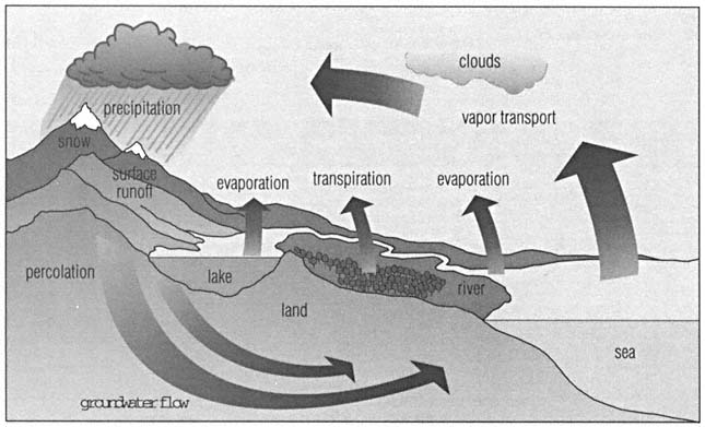


  a strong circumpolar current around Antarctica, which is driven by the "roaring forties" (westerly winds). The currents in the northern Indian Ocean are more complicated and change direction with the c0016-01.gifmonsoon. Some parts of the centers of the main oceanic gyres have very little current, for example the Sargasso Sea, but other areas have recently been shown to contain large eddies that are similar to, but smaller than, depressions and anticyclones in the atmosphere. The source of these eddies is uncertain but one possibility is large meanders that break off from strong western boundary currents such as the Gulf Stream. These eddies are the subject of recent research, as are the deep ocean currents, which have recently been shown to be faster than was previously thought.  


  Thermohaline currents are caused by changes in the density of sea water due to changes in temperature and salinity. They are mainly vertical currents affecting the deep oceans. Deep ocean currents mostly run in the reverse direction to surface currents, in that dense water sinks off Newfoundland and Tierra del Fuego and then drifts toward the equator in deep western boundary currents. In the Arctic the sinking occurs because of the cooling of Arctic water in winter, whereas in the Antarctic it is because of an increase in salinity, and hence density, due to surface sea water freezing. The return vertical flow of this thermohaline circulation occurs as a very slow rise in dense deep water toward the surface over most of the ocean. This rise is a result of winds blowing over the water which increases the depth of the wind-mixed layer and the thermocline bringing up denser water from below. These upwelling currents, such as the Gulf of Guinea Current and the Peru (Humboldt) Current, provide food for plankton, which in turn supports fish and sea birds. At approximate five-to-eight-year intervals, the Peru Current that runs from the Antarctic up the west coast of South America, turns warm, with heavy rain and rough seas, and has disastrous results for Peruvian wildlife and for the anchovy industry. The phenomenon is called El Niño (see below).  


  Ocean circulation and currents play a dominant role in the climate of oceanic land margins. The ocean is warmer than the land in winter and cooler in summer, so that the climate of coastal regions is equable in that annual temperature variations are smaller than in the  


Page 282
   
 
  center of large land masses, where the climate is extreme. Warm and cold ocean currents can produce climatic contrasts in places at similar latitudes, for example western Europe and eastern Canada.  


  El Niño El Niño (Spanish "the child") is a warm ocean surge of the Peru Current, so called because it tends to occur at Christmas, recurring about every five to eight years in the eastern Pacific off South America. It involves a change in the direction of ocean currents, which prevents the upwelling of cold, nutrient-rich waters along the coast of Ecuador and Peru, killing fishes and plants. It is an important factor in global weather.  


  El Niño is believed to be caused by the failure of trade winds and, consequently, of the ocean currents normally driven by these winds. Warm surface waters then flow in from the east. The phenomenon can disrupt the climate of the area disastrously, and has played a part in causing famine in Indonesia, drought and bush fires in the Galápagos Islands, rainstorms in California and South America, and the destruction of Peru's anchovy harvest and wildlife in 1982–1983. El Niño contributed to algal blooms in Australia's drought-stricken rivers and an unprecedented number of typhoons in Japan in 1991. It is also thought to have caused the 1997 drought in Australia and contributed to certain ecological disasters such as bush fires in Indonesia.  
 
 
  El Niño
http://www.pmel.noaa.gov/toga-tao/el-nino/home.html


  Wealth of scientific information about El Niño with animated views of the monthly sea changes brought about by it, El Niño-related climate predictions, and forecasts from meteorological centers around the world.  


  El Niño usually lasts for about 18 months, but the 1990 occurrence lasted until June 1995; U.S. climatologists estimated this duration to be the longest in 2,000 years. The last prolonged El Niño of 1939–41 caused extensive drought and famine in Bengal. It is understood that there might be a link between El Niño and global warming.  


  In a small way, El Niño effects the entire planet. The wind patterns of the 1998 El Niño have slowed the earth's rotation, adding 0.4 milliseconds to each day, an effect measured on the Very Long Baseline Interferometer (VLBI).  


  By examining animal fossil remains along the west coast of South America, U.S. researchers estimated in 1996 that El Niño began 5,000 years ago.  


  tide The rhythmic rise and fall of the sea level in the earth's oceans and their inlets and estuaries are called tides. Tides are due to the gravitational attraction of the moon and, to a lesser extent, the sun, affecting regions of the earth unequally as it rotates. Water on the side of the earth nearest the moon feels the moon's pull and accumulates directly below it, producing high tide.  


  0282-01.jpg  


  tide The gravitational pull of the moon is
the main cause of the tides. Water on the
side of the earth nearest the moon feels
the moon's pull and accumulates directly
under the moon. When the sun and the
moon are in line, at new and full moon,
the gravitational pull of sun and moon
are in line and produce a high spring
tide. When the sun and moon are at
right angles, lower neap tides occur.


  High tide occurs at intervals of 12 hr 24 min 30 sec. The maximum high tides, or spring tides, occur at or near new and full moon when the moon and sun are in line and exert the greatest combined gravitational pull. Lower high tides, or neap tides, occur when the moon is in its first or third quarter and the moon and sun are at right angles to each other.  


  wave An ocean wave is a ridge or swell of water formed by wind or other causes. The power of a wave is determined by the strength of the wind and the distance of open water over which the wind blows (the fetch). Waves are the main agents of coastal erosion and deposition: sweeping away or building up beaches, creating spits and berms, and wearing down cliffs by their hydraulic action and by the corrosion of the sand and shingle that they carry. A tsunami (misleadingly  


Page 283
   
 
  0283-01.jpg  


  spit Longshore drift carries sand and shingle up coastlines. Deposited
material gradually builds up over time at headlands forming a new stretch
of land called a spit. A spit that extends across a bay is known as a bar.


  called a "tidal wave") is formed after a submarine earthquake.  


  As a wave approaches the shore it is forced to break. Friction with the sea bed causes the wavelenth to decrease, while the shallow depth causes the wave height to increase. The wave eventually becomes unstable and breaks. When it breaks on a beach, water and sediment are carried up the beach as swash; the water then drains back as backwash.  


  A constructive wave causes a net deposition of material on the shore because its swash is stronger than its backwash. Such waves tend be low and have crests that spill over gradually as they break. The backwash of a destructive wave is stronger than its swash, and therefore causes a net removal of material from the shore. Destructive waves are usually tall and have peaked crests that plunge downward as they break, trapping air as they do so.  


  Atmospheric instability caused by the greenhouse effect and global warming appears to be increasing the severity of Atlantic storms and the heights of the ocean waves. Waves in the south Atlantic are shrinking—they are on average half a meter smaller than in the mid-1980s—and those in the northeast Atlantic have doubled in size over the last 40 years. As the height of waves affects the supply of marine food, this could affect fish stocks, and there are also implications for shipping and oil and gas rigs in the north Atlantic, which will need to be strengthened if they are to avoid damage.  


  Freak or "episodic" waves form under particular weather conditions at certain times of the year, traveling long distances in the Atlantic, Indian, and Pacific oceans. They are considered responsible for the sudden disappearance, without distress calls, of many ships.  


  Freak waves become extremely dangerous when they reach the shallow waters of the continental shelves at 100 fathoms (180 m/600 ft), especially when they meet currents: for example, the Agulhas Current to the east of South Africa, and the Gulf Stream in the north Atlantic. A wave height of 34 m/112 ft has been recorded.  


  beach A beach is a strip of land bordering the sea, normally consisting of boulders and pebbles on exposed coasts or sand on sheltered coasts. It is usually defined by the high- and low-water marks. A berm, a ridge of sand and pebbles, may be found at the farthest point that the water reaches.  


  The unconsolidated material of the beach consists of a rocky debris eroded from exposed rocks and headlands by the processes of coastal erosion, or material carried in by rivers. The material is transported to the beach, and along the beach, by longshore drift. Incoming waves (swash) hit the beach at an angle and carry sand onto the beach. Outgoing waves (backwash) draw back at right angles to the beach carrying sand with them. This zigzag pattern results in a net movement of the material in one particular direction along the coast.  


  When the energy of the waves decreases due to interaction with currents or changes in the coastline, more sand is deposited than is transported, building up to create depositional features such as spits, bars, and tombolos.  


  Attempts often are made to artificially halt longshore drift and increase deposition on a beach by erecting barriers (groynes) at right angles to the beach. These barriers cause sand to build up on their upstream side but deplete the beach on the downstream side, causing beach erosion. The finer sand can be moved about by the wind, forming sand dunes.  


  coastal erosion The erosion of the land by the constant battering of the sea's waves is called coastal erosion. Coastal erosion occurs primarily by the processes of hydraulic action, corrasion, attrition, and solution. Frost shattering (or freeze-thaw), caused by the  


Page 284
   
 
  0284-01.jpg  


  longshore drift Waves sometimes hit the beach at an angle. The
incoming waves (swash) carry sand and shingle up onto the shore and
the outgoing wave takes some material away with it. Gradually material is
carried down the shoreline in the same direction as the longshore current.


  expansion of frozen sea water in cavities, and biological weathering, caused by the burrowing of rock-boring mollusks, also result in the breakdown of the coastal rock.  


  Where resistant rocks form headlands, the sea erodes the coast in successive stages. First it exploits weaknesses, such as faults and cracks, in cave openings and then gradually wears away the interior of the caves until their roofs are pierced through to form blowholes. In time, caves at either side of a headland may unite to form a natural arch. When the roof of the arch collapses, a stack is formed. The Old Man of Hoy (137 m/449 ft high), in the Orkney Islands, is a fine example of a stack. Stacks may be worn down further to produce a stump and a wave-cut platform.  


  Beach erosion occurs when more sand is eroded and carried away from the beach than is deposited by longshore drift. Beach erosion can occur due to the construction of artificial barriers, such as groynes, or due to the natural periodicity of the beach cycle, whereby high tides and the high waves of winter storms tend to carry sand away from the beach and deposit it offshore in the form of bars. During the calmer summer season some of this sand is redeposited on the beach.  


  tsunami A tsunami (Japanese "harbor wave") is an ocean wave generated by vertical movements of the sea floor resulting from earthquakes or volcanic activity. Unlike waves generated by surface winds, the entire depth of water is involved in the wave motion. In the open ocean the tsunami takes the form of several successive waves, rarely in excess of 1 m/3 ft in height but traveling at speeds of 650–800 kph/400–500 mph.  


  0284-02.jpg  


  coastal erosion Typical features of coastal erosion: from the initial cracks in less
resistant rock through to arches, stacks, and stumps that can occur as erosion progresses.


Page 285
Major Floods and Tsunamis of the 20th Century
Year Event Location
Number of deaths
1911 floods Chang Jiang River, China
100,000
1913 floods Ohio/Indiana, U.S.A.
732
1915 floods Galveston, Texas, U.S.A.
275
1918 tsunami Kuril Islands/Russia/Japan/ Hawaü
23
1923 tsunami Kamchatka/Hawaü
3
1931 floods Huang Ho River, China
3,700,000
1939 floods northern China
200,000
1944 tsunami Japan
998
1946 tsunami Japan
1,997
  tsunami Aleutian Islands/Hawaü, U.S.A. California, U.S.A.
159
1949 floods China
57,000
1952 tsunami Kamchatka/Kuril Islands/Hawaü,
many
1953 floods northwestern Europe
1,794
1954 floods China
40,000
  floods Farhzad, Iran
2,000
1955 floods India/Pakistan
1,700
1959 floods western Mexico
2,000
  flood Fréjus, France
412
1960 tsunami Chile/Hawaü/Japan
5,000
  floods Bangladesh
10,000
1962 floods North Sea coast, Germany
343
  floods Barcelona, Spain
445
1964 tsunami Alaska/Aleutian Islands/California, U.S.A.
122
1966 floods Brazil
200
  floods Florence, Italy
113
1967 floods Brazil
>300
1969 floods southern California, U.S.A.
100
  floods South Korea
250
  floods Tunisia
500
1970 floods Romania
160
  floods Himalayas, India
500
1971 floods Rio de Janeiro, Brazil
130
1972 floods West Virginia, U.S.A.
118
  floods South Dakota, U.S.A.
237
1974 floods Tubaro, Brazil
1,000
  floods Bangladesh
2,500
1976 tsunami Philippines
5,000
  floods Colorado, U.S.A.
139
1978 floods northern India
1,200
1979 tsunami Indonesia
539
  floods Morvi, India
15,000
1981 floods northern China
550
1982 floods Peru
600
  floods Guangdong, China
430
  floods El Salvador/Guatemala
>1,300
1983 tsunami Japan/South Korea
107
1984 floods South Korea
>200
1987 floods northern Bangladesh
>1,000
1988 floods Brazil
289
  floods Bangladesh
>1,300
1990 tsunami Bangladesh
370
  floods Mexico
85
  floods Tanzania
283
1991 floods Afghanistan
1,367
  floods Bangladesh
150,450
  floods Benin
30
  floods Chad
39
  floods/storm Chile
199
  floods China
6,728
  floods India
2,024
  floods Malawi
1,172
  floods Peru
40
  floods/typhoon Philippines
8,890
  floods Romania
138
  floods South Korea
54
  floods Sudan
2,000
  floods Turkey
30
  floods Texas, U.S.A.
33
  floods Vietnam
136
1992 floods Afghanistan
450
  floods Argentina
104
  floods Chile
41
  floods China
197
  floods India
551
  floods Pakistan
1,446
  floods Vietnam
55
1993 floods Indonesia
18
  floods Midwestern U.S.A.
48
1994 floods Moldova
47
  floods southern China
1,400
  floods India
>600
  floods Vietnam
>175
  floods northern Italy
>60
1995 floods Benin
10
  floods Bangladesh
>200
  floods Somalia
20
  floods northwestern Europe
40
  floods Hunan Province, China
1,200
  floods southwestern Morocco
136
  floods Pakistan
>120
  floods South Africa
147
  floods Vietnam
85
1996 floods southern and western India
>300
  floods Tuscany, Italy
30
  floods North and South Korea
86
  floods Pyrenees, France/Spain
84
  floods Yemen
324
  floods central and southern China
2,300
1997 floods west coast, U.S.A.
36
  floods Sikkim, India
>50
  floods Germany/Poland/Czech Republic
>100
  floods Somalia
>1,700
  floods eastern Uganda
>30
  floods Spain and Portugal
70


Page 286
   
 
  In the coastal shallows tsunamis slow down and build up, producing huge swells over 15 m/45 ft high in some cases and over 30 m/90 ft in rare instances. The waves sweep inland causing great loss of life and property. On May 26, 1983 an earthquake in the Pacific Ocean caused tsunamis up to 14 m/42 ft high, which killed 104 people along the west coast of Japan near Minehama, Honshu.  


  Before each wave there may be a sudden withdrawal of water from the beach. Used synonymously with tsunami, the popular term ''tidal wave" is misleading: tsunamis are not caused by the gravitational forces that affect tides.  
 
 
  Tsunami!
http://www.geophys.washington.edu/tsunami/intro.html


  Description of many aspects of tsunamis. Included are details on how a tsunami is generated and how it propagates, how they have affected humans, and how people in coastal areas are warned about them. The site also discusses if and how you may protect yourself from a tsunami and provides "near real-time" tsunami information bulletins.  


  rivers  


  A river is a large body of water that flows down a slope along a channel restricted by adjacent banks and levées (naturally formed raised banks). A river originates at a point called its source, and enters a sea or lake at its mouth. Along its length it may be joined by smaller rivers called tributaries; a river and its tributaries are contained within a drainage basin. The point at which two rivers join is called the confluence.  


  Rivers are formed and molded over time chiefly by the processes of erosion, and by the transport and deposition of sediment (see below). Rivers are able to work on the landscape because the energy stored in the water, or potential energy, is converted as it flows downhill into the kinetic energy used for erosion, transport, and deposition. The amount of potential energy available to a river is proportional to its initial height above sea level. A river follows the path of least resistance downhill, and deepens, widens, and lengthens its channel by erosion.  


  One way of classifying rivers is by their stage of development. A youthful stream is typified by a narrow  


  0286-01.jpg  


  river The course of a river from its source of a spring or melting
glacier, through to maturity where it flows into the sea.


Page 287
   
 
  0287-01.jpg  


  oxbow lake The formation of an oxbow lake. As a river meanders across a flood plain,
the outer bends are gradually eroded and the water channel deepens; as the loops
widen, the neck of the loop narrows and finally gives way, allowing the water to flow
in a more direct route, isolating the old water channel and forming an oxbow lake.


  V-shaped valley with numerous waterfalls, lakes, and rapids. Because of the steep gradient of the topography and the river's height above sea level, the rate of erosion is greater than the rate of deposition and downcutting occurs by vertical corrasion. These characteristics may also be said to typify a river's upper course.  


  In a mature river, the topography has been eroded down over time and the river's course has a shallow  
 
Longest Rivers in the World
River Location
Approximate
length
   
km
mi
Nile Africa
6,695
4,160
Amazon South America
6,570
4,083
Chang Jiang (Yangtze) China
6,300
3,915
Mississippi-Missouri-Red Rock U.S.A.
6,020
3,741
Huang He (Yellow River) China
5,464
3,395
Ob-lrtysh China/Kazakhstan/Russia
5,410
3,362
Amur-Shilka Asia
4,416
2,744
Lena Russia
4,400
2,734
Congo-Zaire Africa
4,374
2,718
Mackenzie-Peace-Finlay Canada
4,241
2,635
Mekong Asia
4,180
2,597
Niger Africa
4,100
2,548
Yenisei Russia
4,100
2,548
Parana Brazil
3,943
2,450
Mississippi U.S.A.
3,779
2,348
Murray-Darling Australia
3,751
2,331
Missouri U.S.A.
3,726
2,315
Volga Russia
3,685
2,290
Madeira Brazil
3,241
2,014
Purus Brazil
3,211
1,995
São Francisco Brazil
3,199
1,988
Yukon U.S.A./Canada
3,185
1,979
Rio Grande U.S.A./Mexico
3,058
1,900
Indus Tibet/Pakistan
2,897
1,800
Danube eastern Europe
2,858
1,776
Japura Brazil
2,816
1,750
Salween Myanmar/China
2,800
1,740
Brahmaputra Asia
2,736
1,700
Euphrates Iraq
2,736
1,700
Tocantins Brazil
2,699
1,677
Zambezi Africa
2,650
1,647
Orinoco Venezuela
2,559
1,590
Paraguay Paraguay
2,549
1,584
Amu Darya Tajikistan/Turkmenistan/ Uzbekistan
2,540
1,578
Ural Russia/Kazakhstan
2,535
1,575
Kolyma Russia
2,513
1,562
Ganges India/Bangladesh
2,510
1,560
Arkansas U.S.A.
2,344
1,459
Colorado U.S.A.
2,333
1,450
Dnieper eastern Europe
2,285
1,420
Syr Darya Asia
2,205
1,370
Irrawaddy Myanmar
2,152
1,337
Orange South Africa
2,092
1,300


Page 288
   
 
  gradient. This mature river is said to be graded. Erosion and deposition are delicately balanced as the river meanders (gently curves back and forth) across the extensive flood plain (sometimes called an inner (delta). Horizontal corrasion is the dominant erosive process. The flood plain is an area of periodic flooding along the course of river valleys made up of fine silty material called alluvium deposited by the flood water. Features of a the mature river (or the lower course of a river) include extensive meanders, oxbow lakes, and braiding.  


  Many important flood plains, such as the inner Niger delta in Mali, occur in arid areas where their exceptional fertility has great importance for the local economy. However, using flood plains as the site of towns and villages involves a certain risk, and it is safer to use flood plains for other uses, such as agriculture and parks. Water engineers can predict when flooding is likely and take action to prevent it by studying hydrographs, graphs showing how the discharge of a river varies with time.  
 
 
  Flood!
http://www.pbs.org/wgbh/nova/flood/


  As a companion to the U.S. Public Broadcasting Service (PBS) television program Nova, this page concerns many aspects of flooding. It takes an historical look at floods and examines the measures that engineers have taken to combat them. Three major rivers are discussed: the Yellow, Nile, and Mississippi. In addition to learning about the negative effects of floods, you can also find out about the benefits that floods bestow on farmland.  


  waterfall A cascade of water in a river or stream is called a waterfall. It occurs when a river flows over a bed of rock that resists erosion; weaker rocks downstream are worn away, creating a steep, vertical drop and a plunge pool into which the water falls. Over time, continuing erosion causes the waterfall to retreat upstream forming a deep valley, or gorge.  


  alluvial deposit An alluvial deposit is a layer of broken rocky matter, or sediment, formed from material that has been carried in suspension by a river or stream and dropped as the velocity of the current decreases. River plains and deltas are made entirely of alluvial deposits, but smaller pockets can be found in the beds of upland torrents.  


  Alluvial deposits can consist of a whole range of particle sizes, from boulders down through cobbles, pebbles, gravel, sand, silt, and clay. The raw materials are the rocks and soils of upland areas that are loosened by erosion and washed away by mountain streams. Much of the world's richest farmland lies on alluvial deposits. These deposits can also provide an economic source of minerals. River currents produce a sorting action, with particles of heavy material deposited first while lighter materials are washed downstream. Hence heavy minerals such as gold and tin, present in the original rocks in small amounts, can be concentrated and deposited on stream beds in commercial quantities. Such deposits are called "placer deposits."  


  0288-01.jpg  


  waterfall When water flows over hard rock and soft rock, the soft
rocks erode creating waterfalls. As the erosion processes continue,
the falls move backward, in the opposite direction of the water


Page 289
Highest Waterfalls in the World
Waterfall Location
Total drop


  m  


  ft  
 
Angel Falls Venezuela
 
 
  979  


  3,212  
 
Yosemite Falls U.S.A.
 
 
  739  


  2,425  
 
Mardalsfossen-South Norway
 
 
  655  


  2,149  
 
Tugela Falls South Africa
 
 
  614  


  2,014  
 
Cuquenan Venezuela
 
 
  610  


  2,000  
 
Sutherland New Zealand
 
 
  580  


  1,903  
 
Ribbon Fall, Yosemite U.S.A.
 
 
  491  


  1,612  
 
Great Karamang River Falls Guyana
 
 
  488  


  1,600  
 
Mardalsfossen-North Norway
 
 
  468  


  1,535  
 
Della Falls Canada
 
 
  440  


  1,443  
 
Gavarnie Falls France
 
 
  422  


  1,385  
 
Skjeggedal Norway
 
 
  420  


  1,378  
 
Glass Falls Brazil
 
 
  404  


  1,325  
 
Krimml Austria
 
 
  400  


  1,312  
 
Trummelbach Falls Switzerland
 
 
  400  


  1,312  
 
Takkakaw Falls Canada
 
 
  366  


  1,200  
 
Silver Strand Falls, Yosemite U.S.A.
 
 
  357  


  1,170  
 
Wallaman Falls Australia
 
 
  346  


  1,137  
 
Wollomombi Australia
 
 
  335  


  1,100  
 
Cusiana River Falls Colombia
 
 
  300  


  984  
 
Giessbach Switzerland
 
 
  300  


  984  
 
Skykkjedalsfossen Norway
 
 
  300  


  984  
 
Staubbach Switzerland
 
 
  300  


  984  


  sediment Sediment is any loose material that has "settled"—deposited from suspension in water, ice, or air, generally as the water current or wind speed decreases. Typical sediments are, in order of increasing coarseness, clay, mud, silt, sand, gravel, pebbles, cobbles, and boulders.  


  Sediments differ from sedimentary rocks in which deposits are fused together in a solid mass of rock by a process called lithification. Pebbles are cemented into conglomerates; sands become sandstones; muds become mudstones or shales; peat is transformed into coal.  


  sand The term "sand" refers to loose grains of rock, sized 0.0625–2.00 mm/0.0025–0.08 in in diameter, consisting most commonly of quartz, but owing their varying color to mixtures of other minerals. Sand is used in cement-making, as an abrasive, in glassmaking, and for other purposes. Sands are classified into marine, freshwater, glacial, and terrestrial. Some "light" soils contain up to 50% sand. Sands may eventually consolidate into sandstone.  


  ground water  


  Water collected underground in porous rock strata and soils is termed ground water; it emerges at the surface as springs and streams. The ground water's upper level is called the water table. Sandy or other kinds of beds that are filled with ground water are called aquifers. Recent estimates are that usable ground water amounts to more than 90% of all the fresh water on earth; however, keeping such supplies free of pollutants entering the recharge areas is a critical environmental concern.  


  Most ground water near the surface moves slowly through the ground while the water table stays in the same place. The depth of the water table reflects the balance between the rate of infiltration, called recharge, and the rate of discharge at springs or rivers or pumped water wells. The force of gravity makes underground water run "downhill" underground just as it does on the surface. The greater the slope and the permeability, the greater the speed. Velocities vary from 100 cm/40 in per day to 0.5 cm/0.2 in.  
 
 
  Hydrology
http://www.morll.er.usgs.gov/~bjsmith/outreach/hydrology.primer.html


  Information from the U.S. Geological Survey about all aspects of hydrology. The clickable chapters include facts about surface water and ground water, the work of hydrologists, and careers in hydrology. For answers to further questions click on "ask a hydrologist," which provides links to other U.S. national and regional sources.  


  water table The upper level of ground water is called the water table. Water that is above the water table will drain downward; a spring forms where the water table cuts the surface of the ground. The water table rises and falls in response to rainfall and the rate at which water is extracted, for example, for irrigation and industry.  


  In many irrigated areas the water table is falling due to the extraction of water. Below northern China, for example, the water table is sinking at a rate of 1 m/3 ft a year. Regions with high water tables and dense industrialization have problems with pollution of the water table. In the United States, New Jersey, Florida, and Louisiana have water tables contaminated by both industrial wastes and saline seepage from the ocean.  


  aquifer A body of rock through which appreciable amounts of water can flow is called an aquifer. The rock of an aquifer must be porous and permeable (full  


Page 290
   
 
  0290-01.jpg  


  artesian well In an artesian well, water rises from an underground water-
containing rock layer under its own pressure. Rain falls at one end of the
water-bearing layer, or aquifer, and percolates through the layer. The layer
fills with water up to the level of the water table. Water will flow from a well
under its own pressure if the well head is below the level of the water table.


  of interconnected holes) so that it can conduct water. Aquifers are an important source of fresh water, for example, for drinking and irrigation, in many arid areas of the world, and are exploited by the use of artesian wells.  
 
 
  Edwards Aquifer
http://www.txdirect.net/users/eckhardt/


  Guide to the Edwards Aquifer (a rock formation containing water) in Texas—one of the most prolific artesian aquifers in the world.  


  An aquifer may be underlain, overlain, or sandwiched between less permeable layers, called aquicludes or aquitards, which impede water movement. Sandstones and porous limestones make the best aquifers.  


  artesian well An artesian well is a well that is supplied with water rising naturally from an underground water-saturated rock layer (an aquifer). The water rises from the aquifer under its own pressure. Such a well may be drilled into an aquifer that is confined by impermeable rocks both above and below. If the water table (the top of the region of water saturation) in that aquifer is above the level of the well head, hydrostatic pressure will force the water to the surface.  


  Artesian wells are often overexploited because their water is fresh and easily available, and they eventually become unreliable. There is also some concern that pollutants such as pesticides or nitrates can seep into the aquifers.  


  Much use is made of artesian wells in eastern Australia, where aquifers filled by water in the Great Dividing Range run beneath the arid surface of the Simpson Desert. The artesian well is named for Artois, a French province, where the phenomenon was first observed.  


  0290-02.jpg  


  spring Springs occur where water-laden rock layers (aquifers) reach the surface.
Water will flow from a well whose head is below the water table.


Page 291
   
 
  0291-01.jpg  


  limestone The physical weathering and erosion of a  limestone landscape. The
freezing and thawing of rain and its mild acidic properties cause cracks and
joints to enlarge, forming limestone pavements, potholes, caves, and caverns.


  cave A cave is a roofed—over cavity in the earth's crust. It is usually produced by the action of underground water, or by waves on a seacoast. Inland caves commonly occur in areas underlain by limestone, such as Kentucky and many Balkan regions, where the rocks are soluble in water. A pothole is a vertical hole in rock caused by water descending a crack; it is thus open to the sky.  


  Most inland caves are found in karst regions, because limestone is soluble when exposed to ground water. As the water makes its way along the main joints, fissures, and bedding planes, they are constantly enlarged into potential cave passages, which ultimately join to form a complex network. c0016-01.gifStalactites and stalagmites and columns form due to water rich in calcium carbonate dripping from the roof of the cave. The collapse of the roof of a cave produces features such as natural arches and steep-sided gorges. Limestone caves are usually found just below the water table, wherever limestone outcrops on the surface. The biggest cave in the world is over 70 km/43 mi long, at Holloch, Switzerland.  


  During the ice age, humans began living in caves leaving many layers of debris that archeologists have unearthed and dated in the Old World and the New. They also left cave art, paintings of extinct animals often with hunters on their trail. Cave animals often show loss of pigmentation or sight, and under isolation, specialized species may develop. The scientific study of caves is called speleology.  


  Celebrated caves include the Mammoth Cave in Kentucky, United States, 6.4 km/4 mi long and 38 m/125 ft high; the Caverns of Adelsberg (Postumia) near Trieste, Italy, which extend for many miles; Carlsbad Cave, New Mexico, the largest in the United States; the Cheddar Caves, England; Fingal's Cave, Scotland, which has a range of basalt columns; and Peak Cavern, England.  
 
 
  Cave
http://www.vol.it/MIRROR2/EN/CAVE/virtcave.html


  Browse the mineral wonders unique to the cave environment—from bell canopies and bottlebrushes to splattermites and stalactites.  


  lakes  


  A lake is a body of still water lying in depressed ground without direct communication with the sea. Lakes are common in formerly glaciated regions, along the courses of slow rivers, and in low land near the sea. The main classifications are by origin: glacial lakes, formed by glacial scouring; barrier lakes, formed by landslides and glacial moraines; crater lakes, found in volcanoes; and tectonic lakes, occurring in natural fissures.  


  Crater lakes form in the calderas of extinct volcanoes, for example Crater Lake, Oregon, United States. Subsidence of the roofs of limestone caves in a karst landscape exposes the subterranean stream network and provides a cavity in which a lake can develop. Tectonic lakes form during tectonic movement, as when a rift valley is formed. Lake Tanganyika was created in conjunction with the East African Great Rift Valley. Glaciers produce several distinct types of lake, such as the lochs of Scotland and the Great Lakes of North America.  


Page 292
   
 
  Lakes are mainly freshwater, but salt and bitter lakes are found in areas of low annual rainfall and little surface runoff, so that the rate of evaporation exceeds the rate of inflow, allowing mineral salts to accumulate. The Dead Sea has a salinity of about 250 parts per 1,000 and the Great Salt Lake, Utah, about 220 parts per 1,000. Salinity can also be caused by volcanic gases or fluids, for example Lake Natron, Tanzania.  


  In the 20th century large artificial lakes have been created in connection with hydroelectric and other works. Some lakes have become polluted as a result of human activity. Sometimes eutrophication (a state of overnourishment) occurs, when agricultural fertilizers leaching into lakes cause an explosion of aquatic life, which then depletes the lake's oxygen supply until it is no longer able to support life.  


  glaciers  


  A glacier is a tongue of ice, originating in mountains in snowfields above the snowline, which moves slowly downhill and is constantly replenished from its source. Glaciers form where annual snowfall exceeds annual melting and drainage. The area at the top of the glacier is called the zone of accumulation. The lower area of the glacier is called the ablation zone. In the zone of accumulation, the snow compacts to ice under the weight of the layers above and moves downhill under the force of gravity. The ice moves plastically under pressure, changing its shape and crystalline structure permanently. Partial melting of ice at the sole of the glacier also produces a sliding component of glacial movement, as the ice travels over the bedrock. In the ablation zone, melting occurs and glacial till (boulder clay) is deposited.  


  When a glacier moves over an uneven surface, deep crevasses are formed in rigid upper layers of the ice mass; if it reaches the sea or a lake, it breaks up to form icebergs. A glacier that is formed by one or several valley glaciers at the base of a mountain is called a piedmont glacier. A body of ice that covers a large land surface or continent, for example Greenland or Antarctica, and flows outward in all directions is called an ice sheet.  


  glacial erosion The wearing-down and removal of rocks and soil by a glacier forms impressive landscape features, including glacial troughs (U-shaped valleys), arêtes (steep ridges), corries (enlarged hollows), and pyramidal peaks (high mountain peaks with concave faces).  


  Erosional landforms result from abrasion and plucking of the underlying bedrock. Abrasion is caused by the lodging of rock debris in the sole of the glacier, followed by friction and wearing away of the bedrock as the ice moves. The action is similar to that of sandpaper attached to a block of wood. The results include the polishing and scratching of rock surfaces to form powdered rock flour, and sub-parallel scratches or striations which indicate the direction of ice movement. Plucking is a form of glacial erosion restricted to the lifting and removal of blocks of bedrock already loosened by freeze-thaw activity in joint fracture.  


  The most extensive period of recent glacial erosion was the Pleistocene epoch in the Quaternary period when, over 2 to 3 million years, the polar ice caps repeatedly advanced and retreated. More ancient glacial episodes are also preserved in the geological record, the earliest being in the middle Precambrian and the most extensive in Permo-Carboniferous times.  


  Larger landforms caused by glacial erosion generally possess a streamlined form, as in c0016-01.gifroche moutonnée and c0016-01.gifcorries. A common feature of glacial erosion is the glacial trough. Hanging valleys, with their tributary waterfalls, indicate extensive glacial erosion. The amount of lowering accomplished by glacial erosion has been estimated at 0.05–2.8 mm/0.002–0.11 in per year, a rate of lowering 10 to 20 times that associated with the action of rivers. Depositional landforms cover  


  0292-01.jpg  


  glacial deposition A glacier picks up large boulders and rock debris from the
valley and deposits them at the snout of the glacier when the ice melts. Some
depositedmaterial is carried great distances by the ice to form erratics.


Page 293
   
 
  10% of the earth's surface.  


  Periglacial processes result from frost and snow activity in areas on the margins of an icesheet. Among the most important periglacial processes are frost-weathering and c0016-01.gifsolifluction. Frost-weathering (the alternate freezing and thawing of ice in cracks in the rock) etches the outlines of rock outcrops, exploiting joints and areas of weakness, and results in aprons of scree.  
 
 
  Glaciers
http://www.nsidc.colorado.edu/NSIDC/EDUCATION/GLACIERS/


  Comprehensive information about glaciers from the U.S. National Snow and Ice Data Center. There are explanations of why glaciers form, different kinds of glaciers, and what they may tell us about climate change. There are a number of interesting facts and a bibliography about the compacted tongues of ice which cover 10% of the land surface of our planet.  


  glacial deposition When glacial ice melts, it deposits the material that it has been carrying. The material deposited by a glacier is called till, or boulder clay. It comprises angular particles of all sizes from boulders to clay that are unsorted and lacking in stratification.  


  Unstratified till can be molded by ice to form drumlins, egg-shaped hills. At the snout of the glacier, till piles up to form a ridge called a terminal moraine. Small depositional landforms may also result from glacial deposition, such as kames (small mounds) and kettle holes (small depressions, often filled with water).  


  Stratified till that has been deposited by meltwater is termed fluvio-glacial, because it is essentially deposited by running water. Meltwater flowing away from a glacier will carry some of the till many miles away. This sediment will become rounded (by the water) and, when deposited, will form a gently sloping area called an outwash plain. Several landforms owe their existence to meltwater (fluvioglacial landforms) and include the long ridges called eskers, which form parallel to the direction the ice flows. Meltwater may fill depressions eroded by the ice to form ribbon lakes.  


  Glacial deposits occur in many different locations beneath the ice (subglacial), inside it (englacial), on top of it (supraglacial), at the side of it (marginal), and in front of it (proglacial).  
 
 
  Nova
http://www.pbs.org/wgbh/nova/ice/


  Companion to the U.S. Public Broadcasting Service (PBS) television program Nova, this page provides information about glaciation, the natural changes in climate over the past 60 million years, the greenhouse effect, global warming, and continental movement.  
 
Ice Age: Major Ice Ages
Name Date (years ago)
Pleistocene 1.64 million–10,000
Permo-Carboniferous 330–250 million
Ordovician 440–430 million
Verangian 615–570 million
Sturtian 820–770 million
Gnejso 940–880 million
Huronian 2,700–1,800 million


  ice age The term "ice age" refers to any period of glaciation occurring in earth history, but particularly that in the Pleistocene epoch, immediately preceding historic times. On the North American continent, glaciers reached as far south as the Great Lakes, and an ice sheet spread over northern Europe, leaving its remains as far south as Switzerland.  


  There were several glacial advances separated by interglacial stages during which the ice melted and temperatures were higher than today. Formerly there were thought to have been only three or four glacial advances, but recent research has shown about 20 major incidences. For example, ocean-bed cores record the absence or presence in their various layers of such cold-loving small marine animals as radiolaria, which indicate a fall in ocean temperature at regular intervals. Other ice ages have occurred throughout geological time: there were four in the Precambrian era, one in the Ordovician, and one at the end of the Carboniferous and beginning of the Permian.  


  The occurrence of an ice age is governed by a combination of factors (the Milankovitch hypothesis): (1) the earth's change of attitude in relation to the sun, that is, the way it tilts in a 41,000-year cycle and at the same time wobbles on its axis in a 22,000-year cycle, making the time of its closest approach to the sun come at different seasons; and (2) the 92,000-year cycle of eccentricity in its orbit around the sun, changing it from an elliptical to a near circular orbit, the severest period of an ice age coinciding with the approach to circularity. There is a possibility that the Pleistocene ice age is not yet over. It may reach another maximum in another 60,000 years.  


  The theory of ice ages was first proposed in the 19th century by, among others, the Swiss civil engineer Ignace Venetz in 1821 and the Swiss-born U.S. geologist Louis Agassiz in 1837. (Before, most geologists had believed that the rocks and sediment they left behind were caused by the biblical flood.) The term "ice age" was first used by the German botanist Karl Schimper in 1837.  


Page 294
   
 
  Earth Science Chronology  
 
Earth Science Chronology
c. 15000 B.C. Rising temperatures in the northern hemisphere cause glacial ice sheets to melt and sea levels to rise by 36.6–39.6 m/120–130 ft, causing widespread flooding.
c. 7500 B.C. The ice covering much of the earth has by now melted to roughly modern levels. This destroys many land bridges, for instance across the Mediterranean. The separation of the British Isles from the European mainland occurs about this time.
c. 450 B.C. The Greek historian Herodotus concludes, correctly, that the Nile delta is caused by the deposition of mud carried by the Nile. He declares the Caspian to be an inland sea and not part of the northern ocean as most scholars of the time believe.
c. 400 B.C. Crude rain gauges 46 cm/18 in wide are used in India.
c. 350 B.C. Aristotle writes of the weather and climate in Meteorologica/Meteorology.
c. 250 B.C. Chinese scholars explicitly describe the hydrologic cycle. The idea has been known in China for a century.
c. 240 B.C. The Greek scholar Eratosthenes of Cyrene makes a map of the Nile valley and correctly explains the reasons for the Nile's annual floods as being due to heavy rains in the upper reaches.
c. 100 B.C. The Greek philosopher Poseidonius correlates tides with the lunar cycle.
c. 100 B.C. The Greeks are the first to measure wind direction. They install a wind vane on the Acropolis.
440 The Gaulish town of Ys, in Armorica (modern Brittany), is overwhelmed by a great flood, and submerged beneath the sea—the foundation of many such legends of lost cities.
602 The Yellow River floods in China, with catastrophic results. In order to prevent a repetition of the disaster, the emperor orders a massive project to recut the riverbed channel.
700 Persian scientists make measurements of wind speed using the rotation of windmills.
764 A severe winter freezes the Bosporus linking Europe and Asia Minor and allows the channel to be crossed on foot.
1108 The first embankments are built on the Red River of Dai Viet in order to protect the rice fields from being flooded.
1130 The English monk Adelard of Bath writes Quaestiones naturales/Inquiries into Nature, comprising a series of 76 dialogs discussing scientific topics, including meteorology.
1307 The German scholar Dietrich of Freiburg writes his treatise De iride et radialibus impressionibus/On the Rainbow and Radial Impressions, on optical effects in meteorology, and particularly the rainbow.
1320 The Muslim scientist Al-Farisi writes Tanqih al-Manazur/Correction of the Optics, which includes his theory on the origin of the rainbow.
1340 William Merle of Oxford, England, writes De futura aeris intemperie/On the Future Storm, a treatise on various methods of predicting the weather.
c. 1450 German philosopher Cardinal Nicholas de Cusa devises the first hygrometer for measuring air humidity.
1450 Italian scientist Leone Alberti devises a vane anemometer and makes the first measurements of wind speeds.
1613 Italian scientist Giovan-Franceso Sagredo begins using a Galilean air thermometer to take daily temperature readings in Venice.
1654 Duke Ferdinand II of Tuscany establishes the world's first meteorological office, with Luigi Antinori in charge. Daily reports and temperature readings are provided by observers in Parma, Milan, Bologna, and Florence.
1660 German physicist Otto Von Guericke makes weather forecasts using a water barometer to measure changes in air pressure. He proposes a series of meteorological stations to improve forecasting and discovers the sudden drop in air pressure preceding a violent storm—a discovery that will revolutionize weather forecasting.
1664 German philosopher Athanasius Kircher publishes Mundus subterraneus/The Subterranean World, suggesting that the tides are caused by water moving to and from a subterranean ocean.
1677 English scientist Richard Towneley devises a rain gauge to capture water falling on the roof of his house, and starts to maintain accurate weather records.
1686 English scientist Edmond Halley publishes a map of the world showing the directions of prevailing winds in different regions—the first meteorological chart.
1702 French scientist Guillaume Amontons, in his experiments on thermometers, notes for the first time that, for a constant mass of air, the change in pressure is proportional to the change in temperature.
1735 English lawyer George Hadley describes the circulation of the atmosphere in terms of


Page 295
  large-scale convection cells moving hot air away from the equator and toward the poles.
1740 Scottish mathematician Colin Maclaurin publishes a widely-praised gravitational theory to explain the tides.
June 1752 North American scientist and statesman Benjamin Franklin performs his most famous experiments, flying a kite during a thunderstorm and charging a Leyden jar to which it is connected. He thereby demonstrates the electrical nature of lightning.
1755 The Golden Horn around Constantinople in the Ottoman Empire freezes over in one of the coldest winters on record—the beginning of a "mini Ice Age" that will last several decades.
1760 Russian scientist Mikhail Vasileivich Lomonosov explains the formation of icebergs.
1771 Swiss meteorologist Jean-André Deluc establishes rules for using the barometer to measure altitude and the height of mountains.
1783 Swiss geologist Horace Bénédict de Saussure invents the hair hygrometer to measure humidity. It is based on the principle that hair lengthens when wet.
1803 English meteorologist Luke Howard give names to the cloud types (cirrus, cumulus, stratus, and nimbus), and recognizes that their shapes reflect their causes.
1804–07 German naturalist and explorer Alexander von Humboldt draws maps with isotherms (lines joining locations with the same mean temperature) and isobars (lines joining locations with the same mean barometric pressure).
1805 British navy commander Francis Beaufort devises the Beaufort wind force scale.
Sept 1821 U.S. meteorologist William Redfield discovers that during a hurricane trees are toppled toward the northwest in Connecticut, and toward the southeast 80 km/50 mi further west, demonstrating that tropical storms are cyclones.
1828 Prussian meteorologist Heinrich Wilhelm Dove discovers that winds in tropical storms circulate counterclockwise in the northern hemisphere and clockwise in the southern hemisphere.
1835 French mathematician Gustave Coriolis describes the inertial forces acting on a rotating body that act at right angles to the direction of rotation. The Coriolis force causes wind and current systems to rotate to the right in the northern hemisphere and to the left in the southern.
1835 U.S. meteorologist James Pollard Espy studies the energy sources of storms and explains frontal systems with attendant condensation and precipitation.
1840 Swiss-born U.S. naturalist Jean-Louis Agassiz describes the motion and behavior of lacier. He argues that Europe was covered by great sheets of ice in the geologically recent past.
1844 French scientist Lucien Vidie invents the aneroid barometer. It detects changes in air pressure through the deformation of an evacuated metal tube.
1845–58 Von Humboldt lays the basis of modern geography with the publication of Kosmos/Cosmos, in which he arranges geographic knowledge in a systematic fashion.
1848 The first wind and current charts for the North Atlantic are compiled by U.S. naval officer Matthew Fontaine Maury.
1849 British meteorologist William Reid demonstrates that hurricanes in the northern hemisphere rotate and curve along paths opposite in direction to those in the southern hemisphere.
c. 1850 U.S. physicist Joseph Henry arranges for telegraph offices to have meteorological equipment installed in exchange for weather information telegraphed to the Smithsonian Institution. By 1860 there are over 500 stations involved, and the information allows the production of the first daily weather maps.
1854 U.S. naval officer Matthew Fontaine Maury maps the depth of the North Atlantic to 4,000 fathoms (7,300 m/23,950 ft).
1855 U.S. naval officer Matthew Fontaine Maury publishes Physical Geography of the Sea, the first textbook on oceanography.
1856 French hydraulic engineer Henri Darcy develops a law to estimate the flow of groundwater.
1868 A tsunami over 21 m/66 ft high kills over 25,000 people in Hawaii and Chile.
1868 English meteorologist Alexander Buchan begins the use of weather maps for forecasting, with the publication of a map showing the movement of a cyclonic depression across North America and Europe. It marks the start of modern meteorology.
1872 Scottish physicist William Thomson (Lord Kelvin) develops a sounding-machine (the "Kelvin") for determining depth at sea.
Dec 7, 1872–May 26, 1876 The British ship Challenger undertakes the world's first major oceanographic survey. Under the command of the Scottish naturalist Wyville Thomson, it discovers hundreds of new marine animals, and finds that at 2,000 fathoms the temperature of the ocean is a constant 2.5°C/36.5°F.
1881 Nearly 300,000 people die when a typhoon hits Haiphong, Vietnam.
1882 Scottish physicist Balfour Stewart postulates the existence of an electrically conducting layer of the outer atmosphere (now known as


Page 296
  the ionosphere) to account for the daily variation in the earth's magnetic field.
1882 U.S. meteorologist Elias Loomis publishes the first precipitation map, which shows mean annual precipitation throughout the world, using isohyets connecting places having equal rainfall.
1883 Austrian meteorologist Julius von Hann publishes Handbook of Climatology, which is a compilation of meterological knowledge and world climate.
1884 German meteorologist Vladimir Peter Köppen introduces a classification of the world's climate zones based on the number of months whose temperatures remain above or below certain means.
1895 U.S. meteorologist Jeanette Picard launches the first balloon to be used for atmospheric research.
March 1895 Russian physicist Aleksandr Stepanovich Popov constructs a lightning detector to register atmospheric electrical disturbances, and suggests that it can be used to detect radio waves.
1897 Norwegian meteorologist Vilhelm Bjerknes develops mathematical theorems applicable to the motions of large-scale air masses, which are essential to weather forecasting.
1900 French meteorologist Léon-Philippe Teisserenc de Bort discovers that the earth's atmosphere consists of two main layers: the troposphere, where the temperature continually changes and is responsible for the weather, and the stratosphere, where the temperature is invariant.
1900 German meteorologist Vladimir Peter Köppen develops a mathematical system for classifying climatic types, based on temperature and rainfall. It serves as the basis for subsequent classification systems.
1913 French physicist Charles Fabry discovers the ozone layer in the upper atmosphere.
1919 Norwegian meteorologists Vilhelm and Jakob Bjerknes introduce the term ''front" in meteorology (after the military front), which describes the transition zone between two masses of air differing in density and temperature.
1919 The U.S. Navy develops the Hayes sonic depth finder. It consists of a device that generates sound waves and receives their echo from the ocean floor. A timing device indicates the depth of the water.
1920 Yugoslavian meteorologist and mathematician Milutin Milankovitch shows that the amount of energy, or heat, received by earth from the sun varies with long-term changes in earth's orbit. Decades later, scientists will correlate fluctuations in global temperature to his "Milankovitch cycles."
1922 British meteorologist Lewis Fry Richardson publishes Weather Prediction by Numerical Process, in which he applies the first mathematical techniques to weather forecasting.
1925 British meteorologist Lewis Fry Richardson publishers Weather Prediction by Numerical Process, in which he applies the first mathematical techniques to weather forecasting.
1930 The woods Hole Oceanographic Institution is established in Massachusetts, United States.
June 11, 1930 The first bathysphere, a spherical steel craft for undersea exploration, built by U.S. zoologist William Beebe and U.S. engineer Otis Baron, descends to 435 m/1,428 ft.
Aug 18, 1934 U.S. explorers and biologists William Beebe and Otis Baron descend in a bathysphere to a record 923 m/3,028 ft in the Atlantic off Bermuda.
c. 1935 Airplanes begin to be used for weather reporting.
1935 The U.S. Weather Bureau establishes hurricane forecasting centers.
1935 U.S. seismologist Charles Richter introduces the Richter scale for measuring the magnitude of earthquakes at their epicenter.
1936 The radio meteorograph (radiosonde) is developed by the U.S. Weather Service; it transmits information on temperature, humidity, and barometric pressure from uncrewed balloons. A network of stations is also inaugurated.
c. 1940 Information from uncrewed weather balloons indicates that columns of warm air rise more than 1.6 km/1 mi above the earth and winds form layers in the lower atmosphere, often blowing in different directions.
1945 Single-stage sounding rockets, reaching speeds of 4,800–8,000 kph/3,000–5,000 mph, and a maximum altitude of 160 km/100 mi, are launched carrying instrumentation to gather information about the upper atmosphere.
1946 The first cloud-seeding experiments are conducted in the United States in an attempt to produced rain.
1947 U.S. meteorologist Irving Langmuir carriers out the first hurricane-seeding experiment; 91 kg/200 lb of dry ice is distributed in a storm.
1952 Norwegian-U.S. meteorologist Jacob Bjerknes discovers that centers of low pressure, or cyclones, develop at the fronts that separate different air masses. It leads to improved weather forecasting. He is also the first to use photographs, taken from high-altitude rockets, as a tool in weather analysis and forecasting.


Page 297
1952 U.S. meteorologist establish the first weather station in the Arctic, at Ice Island T-3.
1958 The Equatorial Undercurrent is discovered in the equatorial Pacific Ocean. It has a width of 320–480 km/ 200–300 mi, a height of 200–300 m/650–1,000 ft, and flows 50–150 m/165–500 ft below the surface.
May 1958 Using data from the Explorer rockets, U.S. physicist James Van Allen discovers a belt of radiation around the earth. Now known as the Van Allen belts (additional belts were discovered later), they consist of charged particles from the sun trapped by the earth's magnetic field.
c. 1960 Meteorologists begin to study storm systems using doppler radar, which can detect the speed and direction of moving storms because of the change in frequency of the reflected radar waves.
Jan 23, 1960 Swiss engineer Jacques Piccard and U.S. Navy lieutenant Don Walsh descend to the bottom of Challenger Deep (10,916 m/35,810 ft), off the Pacific island of Guam, in the bathyscaph Trieste, setting a new undersea record.
April 1, 1960 The United States launches TIROS 1 (Television and Infra-Red Observation Satellite). A weather satellite, it is equipped with television cameras, infrared detectors, and videotape recorders. It provides a worldwide weather observation system, along with subsequently launched Tiros satellites.
Aug 18–20, 1961 The U.S. Navy and the U.S. Environmental Sciences Service Administration initiate Project Stormfury, an attempt to modify hurricanes through seeding, by heavily seeding Hurricane Debbie with silver iodide. Wind speeds drop markedly.
June 19, 1963 The U.S. satellite TIROS 7 (Television and Infra-Red Observation Satellite) is launched. It is used by meteorologists to track, forecast, and analyze storms.
1965 French oceanographer Jacques Cousteau heads the Conshelf Saturation Dive Program, which sends six divers 100 m/328 ft down in the Mediterranean for 22 days.
1965 NASA launches GEOS 1 (Geodynamics Experimental Ocean Satellite). Its aim is to provide a three-dimensional map of the world accurate to within 10 m/30 ft.
1966 The National Science Foundation in the United States puts Scripps Institute of Oceanography in charge of the Joint Oceanographic Institutions Deep earth Sampling (JOIDES) project and establishes the Deep Sea Drilling Project (DSDP).
1974 Mexican chemist Mario Molina and U.S. chemist F. Sherwood Rowland warn that the chlorofluorocarbons (CFCs) used in refrigerators and as aerosol propellants may be damaging the atmosphere's ozone layer that filters out much of the sun's ultraviolet radiation.
1974 The Global Atmospheric Research Program (GARP) is launched. An international project, its aim is to provide a greater understanding of the mechanisms of the world's weather by using satellites and by developing a mathematical model of the earth's atmosphere.
May 1974 The United States launches the world's first Synchronous Meteorological Satellite (SMS).
1975 Five new nations, USSR, West Germany, France, Japan, and the United Kingdom join the Deep Sea Drilling Project (DSDP) to form the International Phase of Ocean Drilling (IPOD).
1976–79 The International Magnetosphere Study conducts a three-year observation of the earth's magnetosphere and its effects on the lower stratosphere including the disruptive effects of magnetic storms on communications.
1977 Scientists from the project FAMOUS (French-American Mid-Ocean Undersea Study) in their deep sea submersible vehicle ALVIN discover a host of strange life forms, such as large red and white tube worms, near undersea hot springs heated by ocean-ridge volcanism. The discovery proves the existence of life in extreme conditions.
June 27, 1978 The U.S. satellite Seasat 1 is launched to measure the temperature of sea surfaces, wind and wave movements, ocean currents, and iceberges; it operates for 99 days before its power fails.
1983 U.S. chemist Mark Thiemens and his colleagues demonstrate that the production of ozone in the upper atmosphere causes separation of the two different heavy isotopes of oxygen independent of their masses. The discovery of this non-mass dependent kinetic partitioning of oxygen isotopes provides a new means of tracing the mixing of gases between earth's different layers of atmosphere.
1987 U.S. researchers prove that thunderstorm systems can propel pollutants into the lower stratosphere when they observe high levels of carbon monoxide and nitric acid at high altitude during a thunderstorm.
1991 The European Space Agency's first remote-sensing satellite (ERS-1) is launched into polar orbit to monitor the earth's temperature from space.
1991 The World Ocean Experiment (WOCE) program is set up to monitor ocean temperatures, circulation, and other parameters.
1993 U.S. scientist Albert Bradley develops the Autonomous Benthic Explorer (ABE), a robotic submersible that can descend to depths of 6.4 km/4 mi and remain at such depths for up to one year.


Page 298
July 4, 1994 Electrical flashes known as "Sprites"—upper atmosphere optical phenomena associated with thunderstorms—are first examined by plane, by a team from the University of Alaska Statewide System, Fairbanks, Alaska, United States.
1996 Scientists from the Scott Polar Institute, using data from the European Space Agency's ERS-1 satellite, discover a 14,000-sq-km/5,400-sq-mi, 125-m/410-ft-deep lake, 4 km/2.5 mi under the Antarctic ice sheet. Called Lake Vostok after the Russian ice-drilling station it lies beneath, the ice sheet, which acts as a blanket, and a pressure of 300–400. atmospheres allow the water to remain liquid.
June 11, 1997 French meteorologist Cyril Moulin shows that up to a billion metric tons of dust a year are blown off the arid drought-prone lands surrounding the Sahara Desert in north Africa and carried as far as the U.K. and the Caribbean. The amount has more than doubled in the past 30 years.
Aug 4, 1997 Using computer models, British meteorologist Alan O'Neill demonstrates a connection between the collapse of anchovy fishing in Peru, drought in Australia, and the late arrival of India's monsoons.
July 17, 1998 A 10-m/30-ft tidal wave hits the north coast of Papua New Guinea, inundating several villages and killing an estimated 6,000 people. Of the survivors 70% are adults; a generation of children is wiped out.


  Biographies  


  Agassiz, (Jean) Louis Rodolphe (1807–1873) Swiss-born U.S. paleontologist and geologist who developed the idea of the ice age. He proposed that glaciers, far from being static, were in a constant state of almost imperceptible motion. Finding rocks that had been shifted or abraded, presumably by glaciers, he inferred that in earlier times much of northern Europe had been covered with ice sheets. Etudes sur les glaciers/Studies on Glaciers (1840) developed the original concept of the ice age.  


  Beaufort, Francis (1774–1857) British admiral, hydrographer to the Royal Navy from 1829. He drew up the Beaufort scale for measuring wind speed. The Beaufort Sea in the Arctic Ocean is named for him.  


  Bjerknes, Vilhelm Firman Koren (1862–1951) Norwegian scientist whose theory of polar fronts formed the basis of all modern weather forecasting and meteorological studies. He also developed hydrodynamic models of the oceans and the atmosphere and showed how weather prediction could be carried out on a statistical basis, dependent on the use of mathematical models.  


  Coriolis, Gustave Gaspard de (1792–1843) French physicist. In 1835 he discovered the Coriolis effect, which governs the movements of winds in the atmosphere and currents in the ocean. Investigating the movements of moving parts in machines and other systems relative to the fixed parts, Coriolis explained how the rotation of the earth causes objects moving freely over the surface to follow a curved path relative to the surface. Coriolis was also the first to derive formulas expressing and mechanical work.  


  Crutzen, Paul (1933– ) Dutch meteorologist who shared the 1995 Nobel Prize for Chemistry with the Mexican chemist Mario Molina and the U.S. chemist F. Sherwood Rowland for their work in atmospheric chemistry, particularly concerning the formation and decomposition of ozone. They explained the chemical reactions which are destroying the ozone layer.  


  In 1970 Crutzen discovered that the nitrogen oxides NO and NO2 speed up the breakdown of atmospheric ozone into molecular oxygen. These gases are produced in the atmosphere from nitrous oxide (N20) which is released by microorganisms in the soil. He showed that this process is the main natural method of ozone breakdown. He also discovered that ozone-depleting chemical reactions occur on the surface of cloud particles in the stratosphere.  


  Davis, William Morris (1850–1934) U.S. physical geographer who analyzed landforms. In the 1890s he developed the organizing concept of a regular cycle of erosion, a theory that dominated geomorphology and physical geography for half a century. He proposed a standard stage-by-stage life cycle for a river valley, marked by youth (steep-sided V-shaped valleys), maturity (flood-plain floors), and old age, as the river valley was imperceptibly worn down into the rolling landscape which he termed a "peneplain." On occasion these developments could be punctuated by upthrust, which would rejuvenate the river and initiate new cycles.  


  Fitzroy, Robert (1805–1865) British vice admiral and meteorologist. In 1828 he succeeded to the command of HMS Beagle, then engaged on a survey of the Patagonian coast of South America, and in 1831 was accompanied by naturalist Charles Darwin on a five-year survey. Fitzroy was governor of New Zealand 1843–45. In 1855 the Admiralty founded the Meteorological Office, which issued weather forecasts and charts, under his charge.  


  Forbes, Edward (1815–1854) British naturalist who studied mollusks and made significant contributions to oceanography. He discounted the contemporary conviction that marine life subsisted only close to the sea surface, spectacularly dredging a starfish from a depth of 400 m/1,300 ft in the Mediterranean. His The Natural History of European Seas (1859) was a pioneering oceanographical text. He proposed that Britain had once been joined to the continent by a land bridge.  


Page 299
   
 
  Humboldt, (Friedrich Wilhelm Heinrich) Alexander, Baron von Humboldt (1769–1859) German geophysicist, botanist, geologist, and writer who was a founder of ecology. He aimed to erect a new science, a "physics of the globe," analysing the deep physical interconnectedness of all terrestrial phenomena. He believed that geological phenomena were to be understood in terms of basic physical causes (for example, terrestrial magnetism or rotation). One of the first popularizers of science, he gave a series of lectures later published as Kosmos/Cosmos (1845–62), an account of the relations between physical environment and flora and fauna.  


  In meteorology, he introduced isobars and isotherms on weather maps, made a general study of global temperature and pressure, and instituted a worldwide program for compiling magnetic and weather observations. His studies of American volcanoes demonstrated they corresponded to underlying geological faults; on that basis he deduced that volcanic action had been pivotal in geological history and that many rocks were igneous in origin. In 1804 he discovered that the earth's magnetic field decreased from the poles to the Equator.  


  Lovelock, James Ephraim (1919– ) British scientist who began the study of CFCs in the atmosphere in the 1960s (though he did not predict the damage they cause to the ozone layer) and who later elaborated the Gaia hypothesis. He invented the electron capture detector in the 1950s, a device for measuring minute traces of atmospheric gases.  


  Maury, Matthew Fontaine (1806–1873) U.S. naval officer, founder of the U.S. Naval Oceanographic Office. His system of recording oceanographic data is still used today.  


  Mercator, Gerardus, Latinized form of Gerhard Kremer (1512–1594) Flemish mapmaker who devised the first modern atlas, showing Mercator's projection in which the parallels and meridians on maps are drawn uniformly at 90°. It is often used for navigational charts, because compass courses can be drawn as straight lines, but the true area of countries is increasingly distorted the further north or south they are from the Equator.  


  Nuttall, Thomas (1786–1859) English-born U.S. naturalist who explored the Arkansas, Red, and Columbia rivers. Between 1809 and 1811 he participated in an expedition up the Missouri River. In 1818–20 he explored the Arkansas and Red rivers, and 1834–35 the mouth of the Columbia River. In 1820 he studied the geology of the Mississippi Valley.  


  Powell, John Wesley (1834–1902) U.S. geologist whose enormous and original studies produced lasting insights into erosion by rivers, volcanism, and mountain formation. His greatness as a geologist and geomorphologist stemmed from his capacity to grasp the interconnections of geological and climatic causes. He was appointed director of the U.S. Geological Survey in 1881. He drew attention to the aridity of the American southwest, and campaigned for irrigation projects and dams, for the geological surveys necessary to implement adequate water strategies, and for changes in land policy and farming techniques.  


  Saussure, Horace Bénédict de (1740–1799) Swiss geologist who made the earliest detailed and first-hand study of the Alps. The results of his Alpine survey appeared in his classic work Voyages des Alpes/Travels in the Alps (1779–86).  


  Shaw, (William) Napier (1854–1945) English meteorologist who introduced the millibar as the meteorological unit of atmospheric pressure (in 1909, but not used internationally until 1929). He also invented the tephigram, a thermodynamic diagram widely used in meteorology, in about 1915. He pioneered the study of the upper atmosphere by using instruments carried by kites and high-altitude balloons. His work on pressure fronts formed the basis of a great deal of later work in the field. Shaw's Manual of Meteorology (1926–31) is still a standard reference work.  


  Glossary  


  A  


  abrasion
the effect of c0016-01.gifcorrasion, a type of erosion in which rock fragments scrape and grind away a surface. The rock fragments may be carried by rivers, wind, ice, or the sea. Striations, or grooves, on rock surfaces are common abrasions, caused by the scratching of rock debris embedded in glacier ice.


  abyssal plain
broad expanse of sea floor lying 3–6 km/2–4 mi below sea level. Abyssal plains are found in all the major oceans, and they extend from bordering continental rises to mid-oceanic ridges.


  abyssal zone
dark ocean region 2,000–6,000 m/ 6,500–19,500 ft deep; temperature 4°C/39°F Three-quarters of the area of the deep-ocean floor lies in the abyssal zone, which is too far from the surface for photosynthesis to take place. Some fish and crustaceans living there are blind or have their own light sources. The region above is the bathyal zone; the region below, the hadal zone.


  alluvial fan
roughly triangular sedimentary formation found at the base of slopes. An alluvial fan results when a sediment-laden stream or river rapidly deposits its load of gravel and silt as its speed is reduced on entering a plain.


  anticyclone
area of high atmospheric pressure caused by descending air, which becomes warm and dry. Winds radiate from a calm center, taking a clockwise direction in the northern hemisphere and a counterclockwise direction in the southern hemisphere. Anticyclones are characterized by clear weather and the absence of rain and violent winds. In summer they bring hot, sunny days and in winter they bring fine, frosty spells. Blocking anticyclones, which prevent the normal air circulation of an area, can cause summer droughts and severe winters.


  Appleton layer, or F layer,
band containing ionized gases in the earth's upper atmosphere, at a height of 150–1,000 km/94–625 mi, above the E layer (formerly the


Page 300
   
 
  Kennelly—Heaviside layer). It acts as a dependable reflector of radio signals as it is not affected by atmospheric conditions, although its ionic composition varies with the sunspot cycle.  


  arch
any natural bridgelike land feature formed by erosion. A sea arch is formed from the wave erosion of a headland where the backs of two caves have met and broken through. The roof of the arch eventually collapses to leave part of the headland isolated in the sea as a c0016-01.gifstack. A natural bridge is formed on land by wind or water erosion and spans a valley or ravine.


  arête
sharp narrow ridge separating two c0016-01.gifglacial troughs (valleys), or c0016-01.gifcorries. The typical U-shaped cross sections of glacial troughs give arêtes very steep sides. Arêtes are common in glaciated mountain regions such as the Rockies, the Himalayas, and the Alps.


  attrition
process by which particles of rock being transported by river, wind, or sea are rounded and gradually reduced in size by being struck against one another. The rounding of particles is a good indication of how far they have been transported. This is particularly true for particles carried by rivers, which become more rounded as the distance downstream increases.


  avalanche
fall or flow of a mass of snow and ice down a steep slope under the force of gravity. Avalanches occur because of the unstable nature of snow masses in mountain areas.


  B  


  barometer
instrument that measures atmospheric pressure as an indication of weather. Most often used are the mercury barometer and the aneroid barometer.


  barrier island
long island of sand, lying offshore and parallel to the coast. Some barrier islands are over 100 km/60 mi in length. Most are derived from marine sands piled up by shallow c0016-01.giflongshore currents that sweep sand parallel to the seashore. Others are derived from former c0016-01.gifspits, connected to land and built up by drifted sand, that were later severed from the mainland.


  barrier reef
coral reef that lies offshore, separated from the mainland by a shallow lagoon.


  bathyal zone
upper part of the ocean, which lies on the continental shelf at a depth of between 200 m/650 ft and 2,000 m/6,500 ft.


  bearing
the direction of a fixed point, or the path of a moving object, from a point of observation on the earth's surface, expressed as an angle from the north. Bearings are taken by compass and are measured in degrees (°), given as threedigit numbers increasing clockwise. For instance, north is 000°, northeast is 045°, south is 180°, and southwest is 225°.


  biological weathering
form of c0016-01.gifweathering caused by the activities of living organisms—for example, the growth of roots or the burrowing of animals. Tree roots are probably the most significant agents of biological weathering as they are capable of prising apart rocks by growing into cracks and joints.


  C  


  California Current
cold ocean current in the eastern Pacific Ocean flowing southward down the west coast of North America. It is part of the North Pacific gyre (a vast, circular movement of ocean water).


  Canaries Current
cold ocean current in the north Atlantic Ocean flowing southwest from Spain along the northwest coast of Africa. It meets the northern equatorial current at a latitude of 20° N.


  canyon
deep, narrow valley or gorge running through mountains. Canyons are formed by stream down-cutting, usually in arid areas, where the rate of down-cutting is greater than the rate of weathering, and where the stream or river receives water from outside the area.


  chemical weathering
form of c0016-01.gifweathering brought about by chemical attack of rocks, usually in the presence of water. Chemical weathering involves the "rotting," or breakdown, of the original minerals within a rock to produce new minerals (such as clay minerals, bauxite, and calcite). Some chemicals are dissolved and carried away from the weathering source.


  chlorofluorocarbon (CFC)
synthetic chemical that is odorless, nontoxic, nonflammable, and chemically inert. When CFCs are released into the atmosphere they drift up slowly into the stratosphere where, under the influence of ultraviolet radiation from the sun, they break down into chlorine atoms which destroy the c0016-01.gifozone layer and allow harmful radiation from the sun to reach the earth's surface.


  cirque
steep-sided hollow in the mountainside of a glaciated area. The weight and movement of the ice has ground out the bottom and worn back the sides. A corrie is open at the front, and its sides and back are formed of c0016-01.gifarêtes. There may be a lake in the bottom, called a tarn.


  clay
very fine-grained sedimentary deposit that has undergone a greater or lesser degree of consolidation. When moistened it is plastic, and it hardens on heating, which renders it impermeable. It may be white, gray, red, yellow, blue, or black, depending on its composition. Clay minerals consist largely of hydrous silicates of aluminum and magnesium together with iron, potassium, sodium, and organic substances. The crystals of clay minerals have a layered structure, capable of holding water, and are responsible for its plastic properties. According to international classification, in mechanical analysis of soil, clay has a grain size of less than 0.002 mm/ 0.00008 in.


  condensation
process by which water vapor turns into fine water droplets to form clouds. Condensation in the atmosphere occurs when the air becomes completely saturated and is unable to hold any more water vapor. As air rises it cools and contracts—the cooler it becomes the less water it can hold. Rain is frequently associated with warm weather fronts because the air rises and cools, allowing the water vapor to condense as rain. The temperature at which the air becomes saturated is known as the dew point. Water vapor will not condense in air if there are not enough condensation nuclei (particles of dust, smoke or salt) for the droplets to form on. It is then said to be supersaturated. Condensation is an important part of the water cycle.


  continental rise
the portion of the ocean floor rising gently from the abyssal plain toward the steeper continental slope. The continental rise is a depositional feature formed from sediments transported down the slope mainly by turbidity


Page 301
   
 
  currents. Much of the continental rise consists of coalescing submarine alluvial fans bordering the continental slope.  


  continental shelf
the submerged edge of a continent, a gently sloping plain that extends into the ocean. It typically has a gradient of less than 1°. When the angle of the sea bed increases to 1°–5° (usually several hundred miles away from land), it becomes known as the continental slope.


  continental slope
sloping, submarine portion of a continent. It extends downward from the edge of the continental shelf. In some places, such as south of the Aleutian Islands of Alaska, continental slopes extend directly to the ocean deeps or abyssal plain. In others, such as the east coast of North America, they grade into the gentler continental rises that in turn grade into the abyssal plains.


  Coriolis effect
the effect of the earth's rotation on the atmosphere and on all objects on the earth's surface. In the northern hemisphere it causes moving objects and currents to be deflected to the right; in the southern hemisphere it causes deflection to the left. The effect is named for its discoverer, Gaspard de Coriolis.


  corrasion
the grinding away of solid rock surfaces by particles carried by water, ice, and wind. It is generally held to be the most significant form of erosion. As the eroding particles are carried along they become eroded themselves due to the process of c0016-01.gifattrition.


  corrosion
alternative term for c0016-01.gifsolution, the process by which water dissolves rocks such as limestone.


  crevasse
deep crack in the surface of a glacier; it can reach several meters in depth. Crevasses often occur where a glacier flows over the break of a slope, because the upper layers of ice are unable to stretch and cracks result. Crevasses may also form at the edges of glaciers owing to friction with the bedrock.


  cyclone
alternative name for a depression, an area of low atmospheric pressure. A severe cyclone that forms in the tropics is called a tropical cyclone or hurricane.


  D  


  delta
tract of land at a river's mouth, composed of silt deposited as the water slows on entering the sea. Familiar examples of large deltas are those of the Mississippi, Ganges and Brahmaputra, Rhône, Po, Danube, and Nile; the shape of the Nile delta is like the Greek letter delta [Delta], and thus gave rise to the name.


  devil wind
minor form of tornado, usually occurring in fine weather; formed from rising thermals of warm air (as is a c0016-01.gifcyclone). A fire creates a similar updraft.


  dew
precipitation in the form of moisture that collects on the ground. It forms after the temperature of the ground has fallen below the dew point of the air in contact with it. As the temperature falls during the night, the air and its water vapor become chilled, and condensation takes place on the cooled surfaces.


  doldrums
area of low atmospheric pressure along the Equator, in the intertropical convergence zone where the northeast and southeast c0016-01.giftrade winds converge. The doldrums are characterized by calm or very light winds, during which there may be sudden squalls and stormy weather. For this reason the areas are avoided as far as possible by sailing ships.


  dune
mound or ridge of wind-drifted sand common on coasts and in deserts. Loose sand is blown and bounced along by the wind, up the windward side of a dune. The sand particles then fall to rest on the lee side, while more are blown up from the windward side. In this way a dune moves gradually downwind.


  drumlin
long streamlined hill created in formerly glaciated areas. Rocky debris (till) is gathered up by the glacial icesheet and molded to form an egg-shaped mound, 8–60 m/25–200 ft in height and 0.5–1 km/0.3–0.6 mi in length. Drumlins commonly occur in groups on the floors of c0016-01.gifglacial troughs, producing a "basket-of-eggs" landscape. They are important indicators of the direction of ice flow, as their blunt end points upstream and their gentler slopes trail off downstream.


  E  


  Ekman spiral effect
in oceanography, theoretical description of a consequence of the c0016-01.gifCoriolis effect on ocean currents, whereby currents flow at an angle to the winds that drive them. It derives its name from the Swedish oceanographer Vagn Ekman (1874–1954).


  esker
narrow, steep-walled ridge, often sinuous and sometimes branching, formed beneath a glacier. It is made of sands and gravels, and represents the course of a subglacial river channel. Eskers vary in height from 3–30 m/10–100 ft and can be up to 160 km/100 mi or so in length.


  exosphere
uppermost layer of the atmosphere. It is an illdefined zone above the thermosphere, beginning at about 700 km/435 mi and fading off into the vacuum of space. The gases are extremely thin, with hydrogen as the main constituent.


  F  


  fjord, or fiord,
narrow sea inlet enclosed by high cliffs. Fjords are found in Norway, New Zealand, and western parts of Scotland. They are formed when an overdeepened U-shaped glacial valley is drowned by a rise in sea-level. At the mouth of the fjord there is a characteristic lip causing a shallowing of the water. This is due to reduced glacial erosion and the deposition of c0016-01.gifmoraine at this point.


  flooding
inundation of land that is not normally covered with water. Flooding from rivers commonly takes place after heavy rainfall or in the spring after winter snows have melted. The river's discharge (volume of water carried in a given period) becomes too great, and water spills over the banks onto the surrounding flood plain. Small floods may happen once a year—these are called annual floods and are said to have a one-year return period. Much larger floods may occur on average only once every 50 years.


  flood plain
area of periodic flooding along the course of river valleys. When river discharge exceeds the capacity of the channel, water rises over the channel banks and floods the adjacent low-lying lands. As water spills out of the channel some alluvium (silty material) will be deposited on the banks to form c0016-01.giflevees (raised river banks). This water will slowly seep into the flood plain, depositing a new layer of rich fertile alluvium as it does so. Many important flood plains,


Page 302
   
 
  such as the inner Niger delta in Mali, occur in arid areas where their exceptional productivity has great importance for the local economy.  


  G  


  geomorphology
branch of geology that deals with the nature and origin of surface landforms such as mountains, valleys, plains, and plateaus.


  glacial trough, or U-shaped valley
steep-sided, flat-bottomed valley formed by a glacier. The erosive action of the glacier and of the debris carried by it results in the formation not only of the trough itself but also of a number of associated features, such as truncated spurs (projections of rock that have been sheared off by the ice) and c0016-01.gifhanging valleys. Features characteristic of glacial deposition, such as c0016-01.gifdrumlins and c0016-01.gifeskers, are commonly found on the floor of the trough, together with linear lakes called ribbon lakes.


  glacier budget
in a glacier, the balance between accumulation (the addition of snow and ice to the glacier) and ablation (the loss of snow and ice by melting and evaporation). If accumulation exceeds ablation the glacier will advance; if ablation exceeds accumulation it will probably retreat.


  geyser
natural spring that intermittently discharges an explosive column of steam and hot water into the air due to the build-up of steam in underground chambers. One of the most remarkable geysers is Old Faithful, in Yellowstone National Park, Wyoming, United States. Geysers also occur in New Zealand and Iceland.


  gorge
narrow steep-sided valley (or canyon) that may or may not have a river at the bottom. A gorge may be formed as a waterfall retreats upstream, eroding away the rock at the base of a river valley; or it may be caused by rejuvenation, when a river begins to cut downward into its channel once again (for example, in response to a fall in sea level). Gorges are common in limestone country, where they may be formed by the collapse of the roofs of underground caverns.


  gravel
coarse sediment consisting of pebbles or small fragments of rock, originating in the beds of lakes and streams or on beaches. Gravel is quarried for use in road building, railway ballast, and for an aggregate in concrete. It is obtained from quarries known as gravel pits, where it is often found mixed with sand or clay.


  Gulf Stream
warm ocean current that flows north from the warm waters of the Gulf of Mexico along the east coast of America, from which it is separated by a channel of cold water originating in the southerly Labrador current. Off Newfoundland, part of the current is diverted east across the Atlantic, where it is known as the North Atlantic Drift, dividing to flow north and south, and warming what would otherwise be a colder climate in the British Isles and northwest Europe.


  gyre
circular surface rotation of ocean water in each major sea (a type of current). Gyres are large and permanent, and occupy the northern and southern halves of the three major oceans. Their movements are dictated by the prevailing winds and the c0016-01.gifCoriolis effect. Gyres move clockwise in the northern hemisphere and counterclockwise in the southern hemisphere.


  H  


  hadal zone
the deepest level of the ocean, below the c0016-01.gifabyssal zone, at depths greater than 6,000 m/19,500 ft. The ocean trenches are in the hadal zone. There is no light in this zone and pressure is over 600 times greater than atmospheric pressure.


  hanging valley
valley that joins a larger c0016-01.gifglacial trough at a higher level than the trough floor. During glaciation the ice in the smaller valley was unable to erode as deeply as the ice in the trough, and so the valley was left perched high on the side of the trough when the ice retreated. A river or stream flowing along the hanging valley often forms a waterfall as it enters the trough.


  headward erosion
backward erosion of material at the source of a river or stream. Broken rock and soil at the source are carried away by the river, causing erosion to take place in the opposite direction to the river's flow. The resulting lowering of the land behind the source may, over time, cause the river to cut backward into a neighboring valley to "capture" another river (see c0016-01.gifriver capture).


  heat island
large town or city that is warmer than the surrounding countryside. The difference in temperature is most pronounced during the winter, when the heat given off by the city's houses, offices, factories, and vehicles raises the temperature of the air by a few degrees.


  hydraulic action
erosive force exerted by water (as distinct from the forces exerted by rocky particles carried by water). It can wear away the banks of a river, particularly at the outer curve of a meander (bend in the river), where the current flows most strongly.


  Hydraulic action occurs as a river tumbles over a waterfall to crash onto the rocks below. It will lead to the formation of a plunge pool below the waterfall. The hydraulic action of ocean waves and turbulent currents forces air into rock cracks, and therefore brings about erosion by cavitation.  


  hydrology
study of the location and movement of inland water, both frozen and liquid, above and below ground. It is applied to major civil engineering projects such as irrigation schemes, dams, and hydroelectric power, and in planning water supply.


  hygrometer
instrument for measuring the humidity, or water vapor content, of a gas (usually air). A wet and dry bulb hygrometer consists of two vertical thermometers, with one of the bulbs covered in absorbent cloth dipped into water. As the water evaporates, the bulb cools, producing a temperature difference between the two thermometers. The amount of evaporation, and hence cooling of the wet bulb, depends on the relative humidity of the air.


  I  


  Ice Age, Little
period of particularly severe winters that gripped northern Europe between the 13th and 17th centuries. Contemporary writings and paintings show that Alpine glaciers were much more extensive than at present, and rivers such as the Thames in the U.K., which do not ice over today, were so frozen that festivals could be held on them.


  iceberg
floating mass of ice, about 80% of which is submerged, rising sometimes to 100 m/300 ft above sea level. Glaciers that reach the coast become extended into a broad foot; as this enters the sea, masses break off and drift toward temperate latitudes, becoming a danger to shipping.


  isobar
line drawn on maps and weather charts linking all places with the same atmospheric pressure (usually measured


Page 303
   
 
  in millibars). When used in weather forecasting, the distance between the isobars is an indication of the barometric gradient (the rate of change in pressure).  


  J  


  jet stream
narrow band of very fast wind (velocities of over 150 kph/95 mph) found at altitudes of 10–16 km/6–10 mi in the upper troposphere or lower stratosphere. Jet streams usually occur about the latitudes of the c0016-01.gifWesterlies (35°–60°).


  K  


  karst
landscape characterized by remarkable surface and underground forms, created as a result of the action of water on permeable limestone. Limestone is soluble in the weak acid of rainwater. Erosion takes place most swiftly along cracks and joints in the limestone and these open up into gullies called grikes. The rounded blocks left upstanding between them are called clints.


  Kuroshio, or Japan Current
warm ocean current flowing from Japan to North America.


  L  


  lagoon
coastal body of shallow salt water, usually with limited access to the sea. The term is normally used to describe the shallow sea area cut off by a coral reef or barrier islands.


  levée
naturally formed raised bank along the side of a river channel. When a river overflows its banks, the rate of flow is less than that in the channel, and silt is deposited on the banks. With each successive flood the levée increases in size so that eventually the river may be above the surface of the surrounding flood plain. Notable levées are found on the lower reaches of the Mississippi in the United States and the Po in Italy.


  longshore drift
movement of material along a beach. When a wave breaks obliquely, pebbles are carried up the beach in the direction of the wave (swash). The wave draws back at right angles to the beach (backwash), carrying some pebbles with it. In this way, material moves in a zigzag fashion along a beach.


  M  


  magnetic storm
in meteorology, a sudden disturbance affecting the earth's magnetic field, causing anomalies in radio transmissions and magnetic compasses. It is probably caused by sunspot activity.


  Mariana Trench
lowest region on the earth's surface; the deepest part of the seafloor. The trench is 2,400 km/1,500 mi long and is situated 300 km/200 mi east of the Mariana Islands, in the northwestern Pacific Ocean. Its deepest part is the gorge known as the Challenger Deep, which extends 11,034 m/36,201 ft below sea level.


  marsh
low-lying wetland. Freshwater marshes are common wherever groundwater, surface springs, streams, or runoff cause frequent flooding or more or less permanent shallow water. A marsh is alkaline whereas a bog is acid. Marshes develop on inorganic silt or clay soils. Large marshes with standing water throughout the year are commonly called swamps. Near the sea, salt marshes may form.


  meander
loop-shaped curve in a mature river flowing sinuously across flat country. As a river flows, any curve in its course is accentuated by the current. On the outside of the curve the velocity, and therefore the erosion, of the current is greatest. Here the river cuts into the outside bank, producing a cutbank or river cliff and the river's deepest point, or thalweg. On the curve's inside the current is slow and deposits any transported material, building up a gentle slipoff slope. As each meander migrates in the direction of its cutbank, the river gradually changes its course across the flood plain.


  meridian
half a great circle drawn on the earth's surface passing through both poles and thus through all places with the same longitude. Terrestrial longitudes are usually measured from the Greenwich Meridian.


  midnight sun
constant appearance of the sun (within the Arctic and Antarctic circles) above the horizon during the summer.


  monsoon
wind pattern that brings seasonally heavy rain to South Asia; it blows toward the sea in winter and toward the land in summer. The monsoon may cause destructive flooding all over India and Southeast Asia from April to September, leaving thousands of people homeless each year.


  moraine
rocky debris or till carried along and deposited by a glacier. Material eroded from the side of a glaciated valley and carried along the glacier's edge is called a lateral moraine; that worn from the valley floor and carried along the base of the glacier is called a ground moraine. Rubble dropped at the snout of a melting glacier is called a terminal moraine.


  O  


  oasis
area of land made fertile by the presence of water near the surface in an otherwise arid region. The occurrence of oases affects the distribution of plants, animals, and people in the desert regions of the world.


  ozone layer
thin layer of the gas ozone in the upper atmosphere that shields the earth from harmful ultraviolet rays.


  P  


  Peru Current
(formerly known as the Humboldt Current) cold ocean current flowing north from the Antarctic along the west coast of South America to southern Ecuador, then west. It reduces the coastal temperature, making the western slopes of the Andes arid because winds are already chilled and dry when they meet the coast.


  physical weathering
type of weathering involving such effects as: frost wedging, in which water trapped in a crack in a rock expands on freezing and splits the rock; sand blasting, in which exposed rock faces are worn away by sand particles blown by the wind; and soil creep, in which soil particles gradually move downhill under the influence of gravity.


  playa
temporary lake in a region of interior drainage. Such lakes are common features in arid desert basins fed by intermittent streams. The streams bring dissolved salts to the lakes, and when the lakes shrink during dry spells, the salts precipitate as evaporite deposits.


  R  


  rainbow
arch in the sky displaying the colors of the spectrum; it is formed by the refraction and reflection of the sun's rays through rain or mist. The countless drops of water in the air each act as a tiny prism, splitting sunlight into the wavelengths of the spectrum.


  ridge of high pressure
elongated area of high atmospheric pressure extending from an c0016-01.gifanticyclone. On a synoptic weather chart it is shown as a pattern of lengthened c0016-01.gifisobars. The weather under a ridge of high pressure is the same as that under an anticyclone.


Page 304
   
 
  river capture
diversion of the headwaters of one river into a neighboring river. River capture occurs when a stream is carrying out rapid c0016-01.gifheadward erosion (backward erosion at its source). Eventually the stream will cut into the course of a neighbouring river, causing the headwaters of that river to be diverted, or "captured."


  roche moutonée
outcrop of tough bedrock having one smooth side and one jagged side, found on the floor of a c0016-01.gifglacial trough. It may be up to 40 m/132 ft high. A roche moutonée is a feature of glacial erosion—as a glacier moved over its surface, ice and debris eroded its upstream side by c0016-01.gifcorrasion, smoothing it and creating long scratches or striations. On the sheltered downstream side fragments of rock were plucked away by the ice, causing it to become steep and jagged.


  S  


  season
period of the year having a characteristic climate. The change in seasons is mainly due to the change in attitude of the earth's axis in relation to the sun, and hence the position of the sun in the sky at a particular place. In temperate latitudes four seasons are recognized: spring, summer, autumn (fall), and winter. Tropical regions have two seasons—the wet and the dry. Monsoon areas around the Indian Ocean have three seasons: the cold, the hot, and the rainy.


  solar pond
natural or artificial "pond," such as the Dead Sea, in which salt becomes more soluble in the sun's heat. Water at the bottom becomes saltier and hotter, and is insulated by the less salty water layer at the top. Temperatures at the bottom reach about 100°C/212°F and can be used to generate electricity.


  solifluction
downhill movement of topsoil that has become saturated with water. Solifluction is common in periglacial environments (those bordering glacial areas) during the summer months, when the frozen topsoil melts to form an unstable soggy mass. This may then flow slowly downhill under gravity to form a solifluction lobe (a tonguelike feature).


  solution
process by which the minerals in a rock are dissolved in water. It is also referred to as corrosion. Solution is one of the processes of erosion as well as weathering (in which the dissolution of rock occurs without transport of the dissolved material). An example of this is when weakly acidic rainfall causes carbonation.


  Solution commonly affects limestone and chalk, both forms of calcium carbonate. It can occur in coastal environments along with corrasion and hydraulic action, producing features like the White Cliffs of Dover, U.K. as well as fluvial (river) environments. In groundwater environments of predominantly limestone, solution produces karst topography, forming features such as sink holes, caves, and limestone pavement.  


  spit
ridge of sand or shingle projecting from the land into a body of water. It is deposited by waves carrying material from one direction to another across the mouth of an inlet (c0016-01.giflongshore drift). Deposition in the brackish water behind a spit may result in the formation of a salt marsh.


  spring
natural flow of water from the ground, formed at the point of intersection of the water table and the ground's surface. The source of water is rain that has percolated through the overlying rocks. During its underground passage, the water may have dissolved mineral substances that may then be precipitated at the spring (hence, a mineral spring).


  stack
isolated pillar of rock that has become separated from a headland by coastal erosion. It is usually formed by the collapse of an c0016-01.gifarch. Further erosion will reduce it to a stump, which is exposed only at low tide.


  stalactite and stalagmite
cave structures formed by the deposition of calcite dissolved in ground water. Stalactites grow downward from the roofs or walls and can be icicle-shaped, straw-shaped, curtain-shaped, or formed as terraces. Stalagmites grow upward from the cave floor and can be conical, fir-cone-shaped, or resemble a stack of saucers. Growing stalactites and stalagmites may meet to form a continuous column from floor to ceiling.


  T  


  tidal wave
common name for a tsunami.


  till, or boulder clay
deposit of clay, mud, gravel, and boulders left by a glacier. It is unsorted, with all sizes of fragments mixed up together, and shows no stratification; that is, it does not form clear layers or beds.


  trade wind
prevailing wind that blows towards the Equator from the northeast and southeast. Trade winds are caused by hot air rising at the Equator and the consequent movement of air from north and south to take its place. The winds are deflected toward the west because of the earth's west-to-east rotation. The unpredictable calms known as the c0016-01.gifdoldrums lie at their convergence.


  tropics
the area between the tropics of Cancer and Capricorn, defined by the parallels of latitude approximately 23°30' north and south of the Equator. They are the limits of the area of earth's surface in which the sun can be directly overhead. The mean monthly temperature is over 20°C/68°F.


  tufa, or travertine
soft, porous, limestone rock, white in color, deposited from solution from carbonate-saturated ground water around hot springs and in caves.


  turbidity current
gravity-driven current in air, water, or another fluid resulting from accumulation of suspended material, such as silt, mud, or volcanic ash, and imparting a density greater than the surrounding fluid. Marine turbidity currents originate from tectonic movement, storm waves, tsunamis (tidal waves), or earthquakes and move rapidly downwards, like underwater avalanches, leaving distinctive deposits called turbidites. They are thought to be one of the mechanisms by which submarine canyons are formed.


  typhoon
violent revolving storm, a hurricane in the western Pacific Ocean.


  W  


  wadi
in arid regions of the Middle East, a steep-sided valley containing an intermittent stream that flows in the wet season.


  weathering
see c0016-01.gifbiological weathering, c0016-01.gifchemical weathering, and c0016-01.gifphysical weathering.


  Westerlies
prevailing winds from the west that occur in both hemispheres between latitudes of about 35° and 60°. Unlike the c0016-01.giftrade winds, they are very variable and produce stormy weather.


  World Meteorological Organization
agency, part of the United Nations since 1950, that promotes the international exchange


Page 305
   
 
  of weather information through the establishment of a worldwide network of meteorological stations. It was founded as the International Meteorological Organization in 1873, and its head-quarters are now in Geneva, Switzerland.  


  Further Reading  


  Abrahamson, D. E. (ed.) The Challenge of Global Warming (1989)  


  Asimov, I. Atom Journey Across the Sub-Atomic Cosmos (1992)  


  Barry, Roger G., and Chorley, Richard J. Atmosphere, Weather and Climate (1992)  


  Bolin, B., and others (eds.) The Greenhouse Effect, Climate and Ecosystems (1986)  


  Bridges, Edwin Michael World Geomorphology (1990)  


  Bryant, Edward Climate: Process and Change (1997)  


  Calder, Nigel The Weather Machine (1974)  


  Calow, Peter, and Petts, Geoffrey E. The Rivers Handbook: Hydrological and Ecological Principles (1992–94; in two volumes)  


  Carter, Bill Coastal Environments: An Introduction to the Physical, Ecological, and Cultural Systems of Coastlines (1988)  


  Cline, W. The Economics of Global Warming (1992)  


  Collard, Roy The Physical Geography of Landscape (1992)  


  Couper, A. The Times Atlas of the Oceans (1989)  


  Dawson, Alastair Ice Age earth (1992)  


  Elsom, D. M. Atmospheric Pollution: A Global Problem (1992)  


  Embleton, Clifford Glaciers and Glacial Erosion (1972)  


  Goudie, A. Climate (1997)  


  Hambrey, M. J. Glacial Environments (1994)  


  Hardy, Ralph; Wright, Peter; Gribbin, John; and Kington,  


  John The Weather Book (1982)  


  Hare, F. Kenneth The Restless Atmosphere (1953–1967; various reprints)  


  Hester, Nigel The Living River (1991)  


  Holford, Ingrid The Guinness Book of Weather Facts and Feats (1982, 2nd edition)  


  Knighton, David Fluvial Forms and Processes (1998, 2nd edition)  


  Komar, Paul D. CRC Handbook of Coastal Processes and Erosion (1983)  


  Leopold, Luna Bergese Water, Rivers, and Creeks (1997)  


  Maclnnis, Joseph Saving the Oceans (1996)  


  Manley, Gordon Climate and the British Scene (1975)  


  Moore, George W. Speleology: Caves and the Cave Environment (1997)  


  Robinson, Peer John, and Henderson-Sellers, Ann Climatology (1998, 2nd edition)  


  Schneider, Stephen H. Encyclopedia of Climate and Weather (1996)  


  Sharp, Robert Phillip Living Ice: Understanding Glaciers and Glaciation (1988)  


  Sparks, Bruce Wilfred Geomorphology (1986, 3rd edition)  


  Walker, H. J., and Graban, W. E. The Evolution of Geomorphology: A Nation-By-Nation Summary of Development (1993)  


  World Survey of Climatology (1969– series)